New book explores the future of land intelligence and geospatial ecosystems.
A new book from University of Melbourne Centre for Spatial Data Infrastructures and Land Administration (CSDILA) researchers explains how GeoAI/GenAI, digital twins, BIM and knowledge graphs are reshaping land administration and the broader geospatial ecosystem.
Titled ‘Land Intelligence and Geospatial Ecosystem: Sustainability, Digital and AI Innovations, and Applications,’ the book has been recently published by CRC Press (Taylor & Francis).
The 336-page, 32-chapter volume collates innovative approaches and applications at the intersection of land administration, geospatial ecosystems and digital transformation.
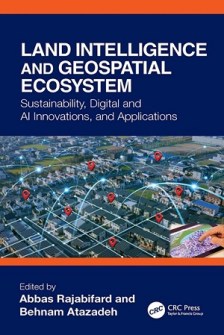
Edited by Professor Abbas Rajabifard and Dr Behnam Atazadeh from CSDILA, the book examines how advances in AI and digital technologies are transforming the ways in which land and geospatial information is captured, managed, integrated, analysed and communicated to support sustainability and resilience.
At the core of the book is the concept of land intelligence — moving beyond conventional land information management towards digital environments capable of transforming complex spatial, legal, and physical data into useful knowledge for location-based decisions.
Topics include:
- AI-driven transformation from data to decisions;
- Ensuring consistency in 3D cadastral datasets;
- BIM for 3D land administration;
- Visualising 3D cadastral information; and
- Using graph databases to connect the legal and physical dimensions of underground utilities.
The volume includes several case studies, prototype systems and models that demonstrate the feasibility of intelligent land administration system design and development.
It also includes applications in affordable housing, infrastructure and asset management, renewable energy, urban governance, and intelligent transport systems.
The publication comes as the land and geospatial sector moves from simply collecting and managing land and geospatial data towards explicating intelligence from these data to enhance resilience and sustainability.
The book should be a suitable reference for professionals, researchers and students working across surveying, GIS, land administration, urban planning, remote sensing, infrastructure engineering, digital construction and related fields.
Related reading:
Land administration expert joins CSDILA