Twelve Australian locations have been included in the latest CEOS list of supersites for calibration and validation of satellite data.
The international Committee on Earth Observation Satellites (CEOS) maintains a list of calibration and validation (cal/val) supersites scattered around the world, which are used to help validate land data products produced from satellite-based observations.
These supersites are globally representative locations that are known to produce consistent, high-quality, verified and traceable reference data. They are chosen to cover a range of ecoclimatic and land cover types, enabling “unbiased satellite data validation at global scale,” according to CEOS.
The long-used list of supersites was put together in 2016 by the CEOS Working Group on Cal/Val (WGCV) Land Product Validation (LPV) Subgroup. The sites selected addressed requirements of the Global Climate Observing System.
Last month, CEOS announced that the list has now been updated and expanded, taking into account changing satellite data product needs, emerging cal/val projects, sensors and sites, and the capabilities of the next generation of satellite missions.
More than 200 sites were considered for inclusion in the 2026 list, but only 90 were chosen.
Australia’s contribution to international cal/val efforts
Of the 90 chosen, 12 are located in Australia and are operated by the Terrestrial Ecosystem Research Network (TERN), Australia’s ecosystem observatory and environmental research network:
- Tumbarumba Wet Eucalypt SuperSite – open wet sclerophyll Eucalyptus forest
- Robson Creek Rainforest SuperSite – simple notophyll vine rainforest
- Litchfield Savanna SuperSite – tropical savanna
- Alice Mulga SuperSite – Mulga and non-Acacia woodland
- Warra Tall Eucalypt SuperSite – wet Eucalyptus obliqua forest
- Gingin Banksia Woodland SuperSite – coastal health Banksia woodland
- Great Western Woodlands SuperSite – temperate woodland
- Whroo Dry Eucalypt SuperSite – box woodland
- Wombat Stringybark Eucalypt SuperSite – Eucalyptus forest
- Cumberland Plain Woodland SuperSite – Eucalyptus species woodland
- Boyagin Wandoo Woodland SuperSite – Wandoo woodland
- Fletcherview Tropical Rangeland SuperSite – tropical rangeland
According to its website, “TERN measures key terrestrial ecosystem attributes over time from continental scale to field sites at hundreds of representative locations and openly provides environmental monitoring and assessment model-ready data that enable those undertaking environment and ecology research to detect and interpret changes in ecosystems.”
Although only 12 were chosen, TERN actually has 16 supersites, which it describes as being intensive ecosystem observatories “set up to facilitate the environmental monitoring process and examine the status and ecosystem processes of one of Australia’s many ecological systems”.
“Each SuperSite comprises a main field site that takes vegetative, faunal and biophysical measurements and works over at least one gradient (topographical or ecological) transect in a typical and important biome in Australia.”
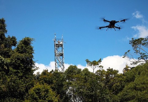
A report released in 2024 found that even though Australia boasts world-class cal/val sites, the current use of these resources is fragmented.
The report stressed the need for a cohesive cal/val network that would improve data quality, support small-sat missions and benefit the broader Earth observation community.
The report recommended:
- Establishing a national cal/val network to support the commercial Earth observation sector.
- Developing a comprehensive repository for cal/val methods, datasets and protocols.
- Leveraging the commercial space sector to maximise the value of existing infrastructure; and
- Piloting an end-to-end cal/val case study for a CubeSat EO mission.
Filling in the cal/val gaps
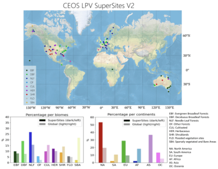
The map at the top of the page shows the global distribution of the 90 supersites, and clearly indicates that many parts of the world are not covered.
According to CEOS, “significant geographical gaps remain, particularly in Africa, South America, and Asia, representing a well-known and challenging issue for global satellite validation networks”.
“Furthermore, a more balanced representation of biomes is still needed. Forest biomes (particularly Deciduous Broadleaf Forests and Needle-Leaf Forests) are overrepresented among the supersites, mainly because many of these locations are part of established ecosystem monitoring networks, such as ICOS [Integrated Carbon Observation System], NEON [National Ecosystem Observatory Network], and TERN.”
“Conversely, other biomes, including shrublands, croplands, and especially sparsely vegetated areas, remain underrepresented.”
CEOS says the gaps will be addressed in future reviews of the supersites, “depending on the availability of new sites and advances in the capabilities of existing ones”.