

A multi-disciplinary military and civil team has conducted a beach survey trial using the latest tech for scanning the shoreline and shallow waters.
It is hoped the work will contribute to a better understanding of how, when and where military operations might be conducted in coastal areas.
In particular, it could benefit the Australian Army, which has a new Littoral Manoeuvre Group that has been given the mission to transport, deploy and support forces in coastal areas and islands.
Team effort for beach survey trial
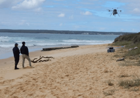
The Multi-Sensor Beach Survey Trial, which was carried out on Currarong Beach on the south coast of New South Wales, saw newer kinds of sensors being put to the test.
The trial brought together experts from the Defence Science and Technology Group (DSTG), the Royal Australian Navy, the Australian Army and researchers from the University of Sydney
“The first question we’re looking to answer is: if we were to augment human ability to survey the beach, what would we augment it with?” said Amelia Eggerking, DSTG maritime autonomy expert and leader of the trial.
“Our intent was to get as many different sensors and systems as we could looking at the same piece of beach in the same timeframe so that we could create a dataset that would allow us to explore those answers,” Eggerking added.
“We’re keen to know the accuracy of the data the sensors collected during the trial and what conditions they were effective in.”
Setting a beach survey baseline
The first step of the trial was for specialist soldiers from the Littoral Manoeuvre Group’s Littoral Riverine Survey Squadron (LRSS) to survey the trial area using traditional methods to establish a baseline.
“We surveyed four kilometres of Currarong Beach with single beam, side-scan and GPS topographical survey to provide both seafloor and land datasets to the research team,” said LRSS littoral surveyor, Corporal Leah Childs.
“It took four days to survey from the five-metre depth contour to the back of the beach where the sand ends, as well as a section of the river.
“It was a good opportunity to speak to the scientists and researchers, and see what equipment, sensors and methodology they were trialling.”
The team then moved on to the trial of other sensor modes, including hyperspectral imaging, laser rangefinding, seabed mapping sonar and video.
Surf zone surveying is challenging
“We understand how many of our sensors and autonomous capabilities work in the littoral because of work we’ve done for mine countermeasures, and how they work in deep water,” said Eggerking.
But Eggerking says the surf zone is more challenging than deeper waters when it comes to conducting a beach survey.
“We were keen to understand how well our systems work where there are lots of bubbles and breaking waves, and the sensors are getting thrown about all over the place,” Eggerking said.
In addition, the water depth continually changes in the surf zone, which can lead to data gaps if the data is derived from traditional surveying methods.
“As surveyors, we do our best, but if the conditions are too dangerous or we’re at risk of grounding our survey vessel, we have to leave a gap in our data,” added Corporal Childs.
“We’re keen to know the accuracy of the data the sensors collected during the trial and what conditions they were effective in.”
The DSTG team is now in the process of analysing the data from the trial.


