

Japanese scientists have used a LiDAR-equipped drone to measure the accumulation of debris from rockfalls on steep slopes.
The University of Tsukuba-led team has used the data to develop a new method to estimate long-term debris supply from steep slopes by measuring debris accumulated on decades-old abandoned roads.
The team says the approach provides a practical means of quantifying debris input to debris-flow source areas.
According to the scientists, debris supplied by rockfall and related slope processes is a key factor influencing the frequency and magnitude of debris flows.
However, estimating the amount of that rockfall debris supplied over several decades has been technically challenging.
In the new study, the team focused on abandoned mountain roads and successfully estimated decadal-scale debris supply by measuring deposits accumulated on these road surfaces using UAV-carried LiDAR.
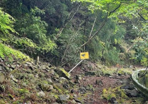
The team chose as its target, a closed section of Shizuoka Prefectural Road 288 near the Shizuoka-Nagano prefectural border. The road became impassable after a disaster in 1991, and rockfall-derived debris has accumulated steadily since then.
Dividing the road into segments, the researchers conducted a high-resolution topographic survey to analyse the relationship between slope topography and debris supply.
The results showed that debris supply increases with steeper mean slope angles and larger contributing areas.
Based on these analyses, headwater slopes in the region were estimated to supply approximately 70 to 93 cubic metres of debris per year, indicating that a sufficient volume of material to trigger a debris flow can accumulate within several decades.
Across Japan’s mountainous regions, the number of abandoned roads is increasing due to route realignment, but these roads have rarely been utilised for scientific observation.
The study demonstrates that UAV-LiDAR surveys of abandoned roads can provide valuable baseline data to support forecasting and risk assessment of debris-flow and landslide hazards.


