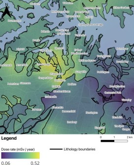
University of Sydney students have made the first high-resolution, ground-based radiation map of the central region Sydney and nearby suburbs.
The result is a finding that the day-to-day level of gamma radiation is entirely normal and safe, and is a result of the rocks upon which the city is built.
The project saw the students survey a 10-square-kilometre area of the city using low-cost, portable gamma-ray spectrometers to collect readings in open spaces such as parks, and even while riding on ferries on Sydney Harbour.
“People often hear the word ‘radioactivity’ and think it’s something dangerous,” said Tengiz Ibrayev, University of Sydney PhD candidate and lead author of the paper (‘Sydney’s first terrestrial gamma-radiation map’) published in the Journal of Environmental Radioactivity.
“But the reality is that radioactivity is a natural part of our environment. It’s in the rocks, the soil — even in food and in our own bodies.”

Radiation from rocks
The results indicate that the average ground-based radiation dose in Sydney is about 0.24 millisieverts per year, with another 0.17 millisieverts deriving from cosmic radiation from space.
This is below the typical global background level, which averages at about 2.4 millisieverts per year.
“The gamma rays won’t be producing any Incredible Hulks anytime soon,” said Dr Laura Manenti, leader of the study.
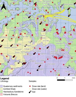
The map shows that suburbs that are built on Hawkesbury sandstone and Ashfield shale (such as Surry Hills, Glebe and some of the Inner West) show slightly higher natural radiation than regions with more recently deposited layers.
Those layers, which are known as quaternary sediments, are found in areas such as Kensington, Centennial Park and parts of Paddington.
The main thing is that all the areas covered were found to be well within natural background limits.
A new approach
According to the paper’s authors, Australia lacks city-scale radiation maps based on ground-level measurements. Airborne survey national maps are available, but their resolution is too low to capture variations within urban environments.
They write that the Sydney study results “demonstrate that high-resolution radiation mapping is achievable through reproducible methods that integrate low-cost, portable detectors and laboratory spectroscopy”.
“Future work will extend this study to include radon mapping and the contribution of anthropogenic sources from urban materials.”
The study was led by Dr Laura Manenti from the School of Physics and conducted by a team that included the aforementioned Tengiz Ibrayev, Honours student Matilda Lawton, Artem Knyazev, a second-year student from NYU Abu Dhabi in Sydney on summer exchange, and others.