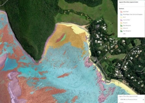
New mapping data reveals the priceless Lord Howe Island lagoon habitat area in 30cm detail.
The new habitat map is based on high-resolution imagery captured during a low-altitude aircraft survey in 2023, funded by the NSW Department of Primary Industries and Regional Development (DPIRD) and the Lord Howe Island Board.
Once DPIRD staff identified key habitat types in the lagoon, the data was then automatically classified at a resolution of 30 cm using object-based image analysis and convolutional neural networks.
The process relied on AI that was trained to interpret imagery based on pixel appearance, recurring patterns and textures across multiple pixels. This was followed up with manual checking, classification and cleaning of the data.
Southernmost coral reef
The Lord Howe Island lagoon is part of the overall Lord Howe Island Marine Park (LHIMP), an internationally significant region.
The sheltered lagoon itself is formed by what is said to be the world’s southernmost coral reef.
The lagoon has a special mix of habitats, such as coral gardens, seaweed reefs, seagrass beds, deep sand holes and rocky shorelines.
These diverse habitats support a range of tropical, subtropical and temperate marine species.
The new habitat map (which is not yet public-facing) will be used for research, monitoring and planning, and for assessing changes made to, or impacts upon, the habitats due to various activities.
Coral at centimetre scale
The Department is conducting ongoing mapping of the lagoon using drones, in collaboration with Southern Cross University.
This extra work provides a fast and cost-effective means of more frequently mapping smaller, targeted areas.
For instance, the maps are being used to assess the impact of, and recovery from, coral bleaching events that occurred during marine heatwaves in 2019 and 2024.
The researchers have developed techniques to automatically and precisely distinguish between healthy and bleached coral at a scale of just centimetres.
One of the main challenges in doing this has been training AI to tell the difference between bleached coral and image pixels that appear white due to water surface sun glint.