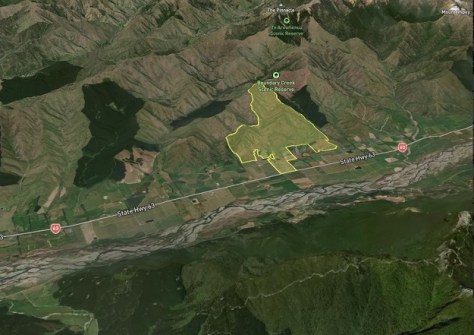
Australian geospatial technology firm, Digital Agricultural Services (DAS), has launched a 3D mapping solution for the regional and rural property sector which, it says, will enable users to easily visualise the topography of hectares of land.
According to the company’s CEO, Anthony Willmott, “Charting topography is a major component of selling land”.
“Significant hills and slopes, existing vegetation and water supplies are defining aspects of a rural property. They can affect its value, its resilience to disasters and the overall use cases,” he said.
DAS says its property industry clients are increasingly seeing a demand to trade properties remotely in order to cater for overseas purchasers, therefore they need tools to visualise the landscape.
According to the Foreign Investment Review Board, the country saw a modest uptick in the percentage of farmland owned by foreign entities, from 12.3% in the 2022 financial year to 12.9% in the 2023 financial year. The majority of overseas owners originate from China and the UK.
Willmott says the company’s 3D mapping solution is a “world-first” innovation.
“While there are a number of tools out there for 3D map rendering, and a plethora of 3D tools for residential and commercial property in particular, there has been no equivalent innovation specifically targeting agri and rural, B2B property ‘walk throughs’ until now,” he said.
“This is because agri/rural has fundamentally different characteristics — such as hills and topography — and unique B2B requirements including property buying and marketing. [Until now] no one has combined the power of geospatial with 3D in a way that directly applies to off-farm decision making or rural property decision-making.”

Willmott says the solution “effectively gives anyone, anywhere the same ‘boots on the ground’ as if they were walking a rural property or farm”.
“This essentially brings the same 3D virtual tour technology that’s well-used with urban properties and applies it to a regional context — in a more granular and meaningful way than Google Earth alone. Think ‘walking through’ a rural property and its ‘layout’ without leaving your home or office.”
According to Willmott, the innovation has come from integrating geospatial technology with DAS’ own paddock boundary data.
“It has previously been impossible to view individual paddock boundary data for all of Australia’s cropping land, select that parcel and view it — with the boundaries highlighted — in 3D,” he said.
“DAS Paddock Boundaries are a vector dataset where polygon geometries represent paddock boundaries. These are owned by DAS and were created by applying machine learning to satellite imagery. The creation method here is a modified ResUnet model, similar to the approach of Waldner et al in 2021.”


