

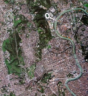
The first image from an IRIDE Earth observation satellite has been released, showing the city of Rome at 2.66-metre resolution.
The image was taken on 5 March by the microsatellite’s multispectral optical instrument from an altitude of 590 kilometres. The resolution of 2.66m is three times higher than currently available for systematic acquisition over Italy.
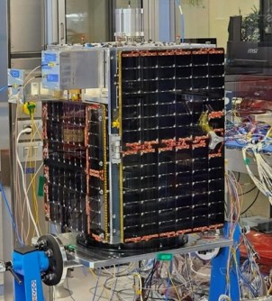
The Pathfinder Hawk spacecraft, which was launched on 14 January, is one of a planned 60 that will comprise a ‘constellation of constellations’ gathering optical, multispectral, hyperspectral and synthetic aperture radar data.
Those six IRIDE constellations will be:
- SAR 1
- SAR 2
- Very high-resolution optical
- Hyperspectral
- High-resolution multispectral 1
- High-resolution multispectral 2
The €1.1 billion IRIDE program was set up by the Italian government and has been developed with funding from Italy’s National Recovery and Resilience Plan. It has been coordinated by the European Space Agency (ESA) with support from the Italian Space Agency (ASI), and involves more than 70 companies from across Italy.
Pathfinder Hawk is described as being an ‘exploratory model satellite’ for one of the IRIDE constellations, Hawk for Earth Observation, which was developed by a consortium led by Turin-based company, Argotec.
IRIDE data will be used to map land cover and coastal zones, as well as air quality.
Applications include protecting cultural and environmental heritage, climate and water resources monitoring, mapping land motion, city planning, studying urban heat islands, and for reacting to emergency and security situations.
“These first images show the extraordinary potential of IRIDE, made possible thanks to the skills and motivation of the teams from ESA, ASI and Italian industry,” said ESA’s Head of Earth Observation Programmes, Simonetta Cheli.
“I would like to congratulate Argotec, Officina Stellare, Exprivia and all the companies involved in the creation of this constellation. Thanks to the trust placed in us by the Italian government and the solid collaboration between ESA and ASI, the programme is proceeding with great success.”
A further nine IRIDE launches are scheduled for the period between June and November 2025, and the program is expected to become fully operational by mid-2026.


