

Australian researchers have responded to a surge in jamming attacks to develop a navigation system that uses visual data from stars rather than relying on the GNSS.
Remote sensing engineers from the University of South Australia have combined celestial navigation with vision-based technology to provide an alternative means of night-time navigation in environments where GNSS is unavailable or unreliable.
UniSA researcher Dr Samuel Teague says the lightweight system can be integrated into standard drones.
“Unlike traditional star-based navigation systems, which are often complex, heavy and costly, our system is simpler, lighter and does not need stabilisation hardware, making it suitable for smaller drones,” Dr Teague says.
“This type of navigation is ideal for operations over oceans, or in warfare zones where GPS jamming is a risk. Apart from the defence sector, it could also be highly useful for environmental monitoring.”
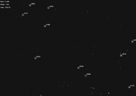
The system relies on an algorithm that uses visual data from stars and processes it through standard autopilot systems.
Senior researcher Professor Javaan Chahl, DST Joint Chair of Sensor Systems in UniSA’s STEM unit, says the technology could enhance the operational capabilities of UAVs across many industries.
“For instance, in environmental monitoring over remote locations or long-endurance surveillance missions where GPS might be unavailable or compromised, this technology offers a valuable new capability,” Prof Chahl says.
“GNSS denial is an increasing challenge, and our research addresses this gap. We have developed a navigation method that’s resilient, independent of external signals, and achievable with low-cost, easily accessible components.
“This makes it applicable to a variety of UAVs, from commercial drones to more advanced defence applications.”
The research has been published in the journal, Drones.


