Image provided by Fugro.
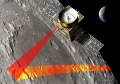
Fugro has announced its RAMMS bathymetric LiDAR system for coastal seafloor surveys.
The firm claims that RAMMS (Rapid Airborne Multibeam Mapping System) offers best-in-class point cloud densities and depth penetration for nearshore coastal mapping.
Commenting on the launch, Ed Saade, president of Fugro USA, described a recent survey the firm completed with the new sensor.
“We believe RAMMS will bring significant value to hydrographic organisations, coastal zone/floodplain managers and engineers,” he said.
“It can achieve 3-Secchi disk depth penetration at a higher observation density than any comparable system on the market – and we’ve recorded seafloor depths as deep as 42 metres during a recent survey,” he said, citing a hydrographic charting demonstration project covering 165 square kilometres recently carried out in Belize.
Developed in partnership with Areté Associates, RAMMS utilises push-broom laser technology, based on military mine-detection techniques. Fugro says that the sensor’s compact size makes depkyment on unmanned fixed-wing aircraft an ideal deployment, and claims rapid processing and transfer times.
Stay up to date by getting stories like this delivered to your mailbox.
Sign up to receive our free weekly Spatial Source newsletter.