Brisbane Airport, Qld, November 2018.
Aerial imagery company Nearmap have released a series of revealing captures of major transport projects around the nation.
Nearmap’s executive, Shane Preston, said that effective transportation systems are critical to ensure our cities remain liveable and sustainable as Australia’s population continues to boom, creeping towards a projected 36 million by 2050.
“There is an onus on geospatial professionals, planners and developers to make use of the modern technology at their fingertips. We operate in a 3D world but we’re still taking a 2D approach to planning,” he said.
“Visualising proposed development sites and their wider surroundings in 3D provides a unique perspective for planners, developers and everyone involved, to drive more efficient, informed and accurate long-term decision making. The outcome… a better connected Australia is a more productive Australia.”
Enjoy Nearmap’s newly-released captures below — click on each to view in full, glorious resolution. Happy World GIS Day!
New South Wales

Light rail depot site, Randwick, NSW, January 2016.

Light rail depot site, Randwick, NSW, August 2017.

Light rail depot site, Randwick, NSW, October 2018.
Western Australia

Redcliff Station, WA, June 2015.

Redcliff Station, WA, June 2017.

Redcliff Station, WA, September 2018.
Victoria

Centre Rd, Clayton, Vic, April 2014.

Centre Rd, Clayton, Vic, February 2017.

Centre Rd, Clayton, Vic, October 2018.
South Australia

Port River Expressway upgrade, SA, March 2013.

Port River Expressway upgrade, SA, July 2014.

Port River Expressway upgrade, SA, September 2018.
Queensland

Brisbane Airport, Qld, November 2014.

Brisbane Airport, Qld, September 2017.
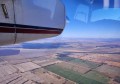
Brisbane Airport, Qld, November 2018.
Stay up to date by getting stories like this delivered to your mailbox.
Sign up to receive our free weekly Spatial Source newsletter.