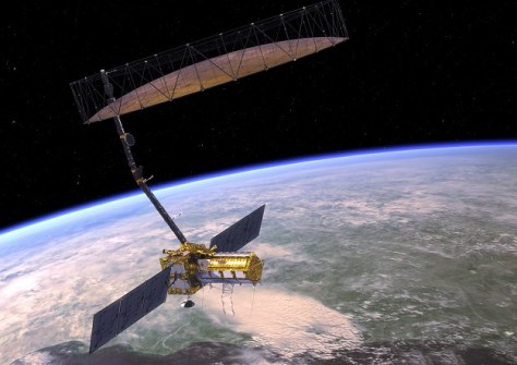
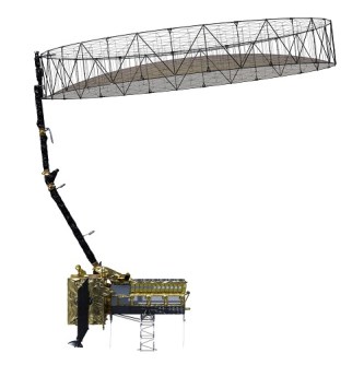
NASA has completed its work on the antenna reflector for the NISAR (NASA ISRO Synthetic Aperture Radar) satellite, and the hardware has arrived in India in preparation for launch in 2025.
The antenna has been delivered to the Indian Space Research Organisation’s (ISRO) spacecraft integration and test facility in Bengaluru, for installation on the NISAR spacecraft.
NISAR will scan nearly all of Earth’s land and ice surfaces twice every 12 days and will thereby help scientists better understand changes in the planet’s surface.
For instance, the data gathered will reveal changes in forests and wetland ecosystems as well as movement and deformation of our planet’s crust due to events such as earthquakes, landslides and volcanic activity.
“This kind of regular observation allows us to look at how Earth’s surface moves across nearly the entire planet,” said Cathleen Jones, NISAR applications lead at NASA’s Jet Propulsion Laboratory (JPL).
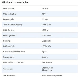
NISAR will be the first satellite to carry both an L-band system (built by JPL) and an S-band system (built by ISRO).
Each instrument can collect measurements day and night and see through clouds that can obstruct the view of optical instruments.
The L-band instrument will also be able to penetrate dense vegetation to measure ground motion. This capability will be especially useful in areas surrounding volcanoes or faults that are obscured by vegetation.
NISAR will also be of interest to those concerned with disaster response, producing data to assist in mitigating and assessing damage.
“The NISAR satellite won’t tell us when earthquakes will happen. Instead, it will help us better understand which areas of the world are most susceptible to significant earthquakes,” said Mark Simons, the US solid Earth science lead for the mission at Caltech.
“From the ISRO perspective, we are particularly interested in the Himalayan plate boundary,” said Sreejith K M, the ISRO solid Earth science lead for NISAR at the Space Applications Centre in Ahmedabad, India.
“The area has produced great magnitude earthquakes in the past, and NISAR will give us unprecedented information on the seismic hazards of the Himalaya.”
NISAR will be launched from the Satish Dhawan Space Centre on India’s southeastern coast in early 2025, with the exact date yet to be determined.