Near real-time imagery available in GIS platforms could soon be a reality.
At least, that is the aim of a new strategic partnership between a GIS superpower and a satellite imagery innovator. UrtheCast and its subsidiary, the Earth Observation company Deimos Imaging, has announced a broad partnership with Esri, aimed at enabling all Esri users to access timely, reliable and quality assured imagery.
Starting with a new UrtheCast imagery service powered by Esri: Kanvas, the service will enable all Esri users to access the imagery, directly into their apps and desktops.
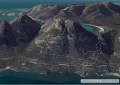
Urthecast is quickly growing a name for itself for their timely, reliable and quality on-the-fly imagery service that uses the Deimos-1 and Deimos-2 satellites. The Candaian company’s long term aim is to create the UrtheDaily constellation, which is expected to image the entire Earth daily at 5m resolution, complimenting Sentinel-2 and Landsat applications.
“Value-added products and services with geo-analytics capabilities are significantly broadening the utility of Earth Observation data,” said Jamie Ritchie, Business Development Director at UrtheCast and Deimos imaging. “The future is in user-focused, real-time apps.”
“The goal of Kanvas is to bring imagery to life by leveraging machine learning algorithms in an integrated environment.
“By partnering with Esri, we are delighted to make available our imagery in ArcGIS, to significantly accelerate decision making in a wide range of fields.”
Lawrie Jordan, Director of Imagery at Esri said that allowing users to create simple, quick, insightful apps, based on timely and qualified imagery, will inspire new solutions in GIS.
“We fully support the upcoming UrtheDaily constellation and see significant interest from our users,” he said. “Delivering daily coverage of the Earth as geo-analytic ready imagery directly into the hands of our users, means that mapping the Earth daily is now a step closer, and the intelligent map a future reality.”
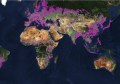
Starting today, anyone with the ArcGIS platform will have free access for three months to the multi-season time series of medium and very-high resolution satellite imagery, over the whole of Spain and California.
Hosted in Amazon Web Services using ArcGIS, Esri users can utilise the multi-temporal imagery service and start building valuable apps for monitoring, change detection, precision insights and more.
Kanvas is being presented at the Esri User Conference in San Diego, July 10-14.