


© iStockphoto/Raul_Mellado
The use of seabed mapping data adds billions to the economy, yet only 25% of Australia’s seabed is fully mapped.
By Jonathan Nally
It is often said that we know less about Earth’s seabed than we do about the surface of the Moon or Mars. There’s a lot of truth in that statement. In some ways, it’s easier to map the surface of those worlds given that we don’t have to peer through a thick layer of ocean. It might also be argued that space scientists have simply been more successful in persuading governments that their work should have higher priority.
Whatever the reasons, one thing is certain: currently only 20% of Earth’s oceans have been mapped from a bathymetric point of view (up from just 6.7% in 2018). That’s according to the ambitious Nippon Foundation–GEBCO 2030 SeaBed Project, which aims to have fully mapped the ocean floor by 2030.
Australia is making a major contribution to the overall effort, through a collaborative national seabed mapping coordination program known as AusSeabed. In 2020–21 alone, more than 2 million square kilometres of seabed data was added to the AusSeabed Data Portal — that’s an area larger than New South Wales, Tasmania and South Australia combined.
AusSeabed is led by Geoscience Australia (GA), but operated by Commonwealth, state and territory government entities, along with universities and industry. According to the program’s website, AusSeabed “provides an open collaboration space where data creators and users can better connect to develop initiatives and products that will improve the quality, discoverability and accessibility of seabed mapping data”.
“We want to know what’s there so we can manage it effectively and sustainably. We want to be able to monitor the state of our ocean as we move forward, we want to know how it changes,” said GA’s Kim Picard during a recent webinar. Picard is a marine geoscientist who led the establishment of the AusSeabed program and has chaired its steering committee since its inception.
Any interested party can join, and the overall spirit of the endeavour is summed up in its approach to data: “collect once, use many times”. While initially focused on bathymetry for seafloor topography, the long term intention is to build a ‘collaboration space’ for other data types, such as sub-bottom profiles, seabed samples and backscatter measurements. AusSeabed also aims to improve access to the data collected.
Deep economics
The aim of mapping Australia’s seabed is not purely scientific, as it is for the study of the Moon or Mars. Economics plays a big part. Maritime activities of all kinds are major contributors to the national economy, and a surprisingly large number of people rely upon seabed data for their livelihoods.
To gauge the extent of this economic activity, Deloitte was commissioned to produce a study for Geoscience Australia that looked at all aspects of the economic value of seabed data and its role in the economy, “including its supply chain and employment effects”. The report was published in October 2021 (https://bit.ly/3x8eFyq).
The report found that, currently, only “around 25 per cent of the seafloor within the Australian Exclusive Economic Zone (EEZ) has been mapped at a resolution suitable to inform sustainable management and use of marine resources”. This essential data is used by numerous industry sectors, including:
- Marine navigation and anchorage
- Resource exploration and extraction
- Fisheries and other bio-product management
- Recreation and tourism
- Coastal and environmental protection
- Marine search, rescue, and recovery
- Hazard identification and risk modelling
- National defence and marine security
- Infrastructure planning and approvals
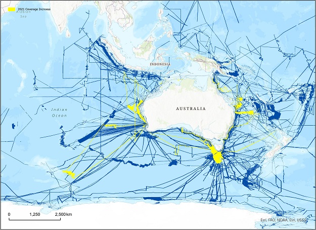
2020–21 coverage map of AusSeabed data holdings available on the Data Portal. New published coverage from contributor datasets are shown in yellow. © Commonwealth of Australia (AusSeabed), CC 4.0 Intl.
In terms of the economic activity and employment generated by seabed mapping, the report found that the “process of producing seabed mapping data directly contributed $51 million to the Australian economy in 2018–19 and employed over 500 FTEs (full-time equivalent)” people. That’s a sizeable industry sector, but it is dwarfed by the wider economic activity and employment that is generated from the data that seabed mapping produces. The report found that:
- In 2018–19, the use of seabed mapping data directly contributed $9 billion to the Australian economy and employed over 56,000 FTEs.
- This direct contribution is bigger than the size of the air and space transport sector and rental and hiring services sector.
- The use of seabed mapping data also creates demand for upstream activities, contributing a further $7 billion in indirect value added to the economy in 2018–19.
- In addition to these figures, there was $37 billion of unlocked economic activities in 2018–19 that is attributable to the use of seabed mapping data during establishment.
The report also concluded that there are “significant social, cultural, and environmental benefits that are attributable to the production and use of seabed mapping data”.
“Seabed mapping data is also often used to understand vulnerability to human impacts, natural hazards such as storm surge, and the physical make-up (geomorphology) of our coastal environments and has been used widely for environmental management, monitoring, and research,” it said.
“Seabed mapping data also holds significant cultural value. It increases traditional owners’ understanding of Sea Country and can reveal culturally significant events, ranging from drowned landforms that may have been occupied by the ancestors of traditional owners, to historical shipwrecks.”
Visibility through data
Just as the Nippon Foundation-GEBCO 2030 SeaBed Project aims to have all the world’s oceans mapped by 2030, so too does the AusSeabed project have a 2030 aim. According to its strategic plan, “By 2030, all available seabed mapping data within the Australian Marine Estate will be readily and openly available, and new data acquisition will take into account the needs of a wide range of users. This will facilitate collaborations between government, research institutions and the private sector while contributing to the blue economy and opening up new avenues for scientific investigation.”
“AusSeabed is a collaborative program, made of all sectors — academic, industry and government — and it extends internationally. It’s very important we work together so we can find the efficiencies and we don’t duplicate the effort,” said Picard. The full list of collaborating entities can be found at https://www.ausseabed.gov.au/about/partners.
“Our mission is to improve the coverage, the awareness, the quality, the discoverability and the accessibility of seabed mapping data to the Australian community,” added Picard. “Our vision is by 2030 we want all of the seabed mapping data that is available within Australia’s marine estate, readily and openly available.”
Stay up to date by getting stories like this delivered to your inbox.
Sign up to receive our free weekly Spatial Source newsletter.


