Half a billion dollars will be injected into the economy by the middle of 2038 through government investment in precise positioning infrastructure, according to a new report commissioned by Geoscience Australia.
The report (PDF), produced by consultancy ACIL Allen, examined the economic benefits of the National Positioning Infrastructure Capability (NPIC) program. It found that a unified approach to the management of the nation’s positioning infrastructure is paying and will continue to pay dividends, enabling more efficient operations across agriculture, construction and mining.
The NPIC is a nationwide network of more than 700 continuously operating global navigation satellite system reference stations (CORS) operated by 11 different organisations. It supports the provision of centimetre-level positioning across most areas that have mobile phone coverage.
According to the report, the Australian Government invested around $64 million into better positioning to support Australian businesses between 1 July 2018 and 30 June 2022 and around $12 million annually from 1 July 2023 to maintain the NPIC program. Of this, around $44 million and $10 million respectively has been directly invested in the NPIC network.
“We know that investment in the NPIC’s positioning infrastructure is having a real impact across our regions and industries, with an expected return of $2.58 in direct benefits for every dollar we spend,” said Ryan Ruddick, GA’s Director of Global Navigational Satellite System Infrastructure.
The report focused on the direct economic impacts of NPIC on four sectors that have been early adopters of precise positioning services: surveying and mapping, agriculture, construction and mining. It also reviewed the impact of NPIC on research and innovation.

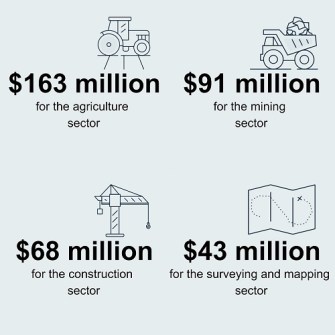
The report found that the NPIC will benefit the national economy to the tune of more than half a billion dollars across two decades, including economic lifts of:
- $163 million in agriculture
- $91 million in mining
- $68 million in construction
- $43 million in surveying and mapping
- $180 million of other, indirect benefits across the entire economy
And the benefits will span the country, providing an estimated $194 million boost in Victoria, $176 million in New South Wales, $101 million in Queensland, $44 million in Western Australia, $16 million in Tasmania and $12 million in South Australia.
The analysis found that only the Northern Territory would experience “a relative negative result due to limited mobile phone coverage outside of the main population centres restricting the ability to deliver precise positioning services over the internet”. But the authors emphasised that this “is a relative effect and does not mean that the Northern Territory economy contracts in absolute terms”.
The report found that there will be a larger relative increase in output in the regions compared to the output of the capital cities because of NPIC, as a result of capital and labour mobility. It says this “reflects in part the fact that the agricultural and mining sectors are largely located in regional areas. A significant component of heavy engineering is also located in regional areas.”
Ruddick pointed out that the use of precise positioning advancements in agriculture “such as auto-steering and yield monitoring systems is delivering productivity and environmental benefits across grain, cotton, sugar, viticulture and horticulture sectors,” adding that “precise positioning used in machine guidance for earthworks is providing increased precision and safety on construction work sites”.
The report also find that precise positioning will have a positive impact on employment across the country, with 2,316 full time jobs expected to have been created over the 20 years to 30 June 2038.


