Following the production of an exhaustive test-bed technical report coupled with a trial economic benefits analysis in August 2019, plus a competitive tender process and finally the awarding of a contract to Lockheed Martin, the SouthPAN service was switched on in September 2022.
SouthPAN is the new Satellite-Based Augmentation System (SBAS) for Australia and New Zealand, supported by both countries’ federal governments. A $1.4 billion investment over 20 years is expected to yield $7.6 billion benefit over 30 years from enhanced positioning across the agriculture, construction, transport and maritime sectors, as well as a host of other geospatial applications.
I attended the Locate conference in May last year and asked several exhibitors, “Hey, what’s your SouthPAN solution?”. The response was variations on “South what?,” combined with some quizzical looks and awkward shuffling. To be fair, it is a very new system, and I was being deliberately provocative.
Salivating, I thought, “What a great idea for a student project!”.
At UNSW, we offer a final-year capstone project, designed to exercise a range of skills previously taught across the program in a group-based activity. There are no lectures and no exams. Students are given a project and self-organise to achieve an ‘outcome’ (see ‘Putting RTK units to the test,’ Roberts, C., Position 120, Aug/Sept 2022).
In the case of this project, the intended outcome was to determine which current GNSS devices offer a SouthPAN service, how does it work, how good is it and how does it compare with other services as well as some commercial GNSS services — and absolutely no RTK! These are the sort of questions we think many potential users are asking, so we decided to ‘lean in’ to the uncertainty and find out.
Preparation
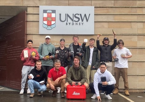
Six weeks prior to the start of term in mid-September 2023, my colleagues and I started contacting GNSS equipment suppliers to loan and test their SouthPAN enabled devices during October. Big thanks go to GPSat Systems/Novatel, C.R. Kennedy/Leica, UPG/Trimble, 4DGlobal/EOS, FrontierSI/Juniper and GMV for supplying their devices and for their ongoing support. When coupled with our school-owned u-blox and EOS Arrow Gold devices, we were able to equip the 12 enrolled students with 12 devices — a logistical triumph!
By the end of our first meeting, the students had started to realise the enormity of the task I had set for them, but were keen for the challenge. They elected a ‘managing director’ and ran proper meetings with minutes, action items and an agenda, rotating the role of chairperson every week. These formal structures help drive the project and enable them to learn valuable soft skills along the way.
The team wrote a combined literature review as a foundation for the technical detail we expected to encounter during testing. With only 10 weeks to design a testbed, test and report, discussions were focused on achieving a useful result. The combined report was to be written as a cookbook for future users, including diagrams, cheat sheets, troubleshooting tips and some results of limited testing. We recognised that this was new not only for all of us, but also for likely readers of the final report.
It took a few weeks to get all systems operating. The combining of the technical expertise of our UNSW staff, the equipment suppliers and the acquired knowledge of the group became a great exercise in communication and collaboration — another soft skill.
Putting it to the test
Because the SouthPAN service was so new, not all devices were SouthPAN capable, therefore some students used analogous commercial GNSS PPP services such as the Novatel Terrastar, SmartNet PPP, Trimble RTX and even the Galileo High Accuracy Service (GalHAS), which is currently not guaranteed in Australia.
Additionally, we recognised that SouthPAN is the first SBAS system to offer three planned service levels: L1 SBAS (sub-metre service), Dual Frequency-Multi-Constellation (DFMC, half-metre service) and a PVS (PPP via SouthPAN, a 10cm to 20cm service).
Despite initial ambitious plans for kinematic and signal blockage testing, as the time raced away the testbed was reduced to a static test for accuracy and precision on a known pillar at 5-, 10- and 30-minute intervals and time to first fix (TTFF). Figure 1 shows a snapshot of the quantitative comparison results from our limited testing for the 30-minute result only.
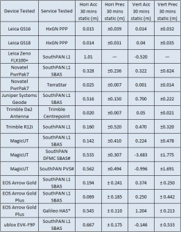
The subscription-based commercial PPP services outperform the SouthPAN L1 service as expected.
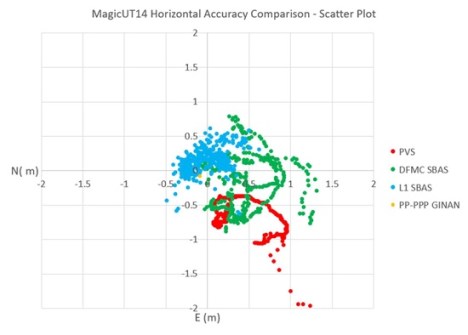
Additionally, RINEX data from the DFMC mode of the GMV Magic UT 14 device was logged and post-processed using Geoscience Australia’s Ginan Open-source PPP software. The configuration of Ginan was set to process the GPS and Galileo constellations using the L1/L5 and E1/E5 signals. IGS Final products were used including correction products such as precise satellite orbit and clock corrections (as well as other correction products) to compute the best possible solution (Figure 2).
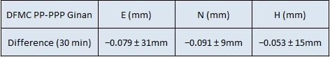
The results of the post-processed PPP solution using Ginan were very encouraging and presented in the table below, showing accuracy from the known coordinate and precision of the result.
The overall conclusions from this exercise demonstrated that the SouthPAN L1 SBAS service is operating well and providing sub-metre accuracy across a range of devices. For surveyors, a taxpayer-funded, free service on your phone offering shovel-width positioning without the need for base stations will be a pretty handy addition to the toolkit.
As expected, the DFMC and PVS services are currently not yet operational in this developing system, but the PP-PPP using Ginan shows great promise. Similarly, early testing of the Galileo HAS showed initial results were possible, and in time, with extra corrections added, will provide another free GNSS positioning service at moderate accuracy. In contrast, the commercial GNSS services (paid subscription) proved more user friendly and were able to provide higher-quality positioning results (cm-level) than those using SouthPAN.
Overall, this was an educational exercise to expose senior undergraduate students to non-RTK, modern GNSS positioning. It required a deeper knowledge of multi-GNSS signals, data formats, hardware, software, datum conversions/transformations, trial-and-error and a host of soft-skills to realise a final result in just 11 weeks.
I want to thank my colleagues, Peter Mumford and Dr Badal Pokharel, and the commitment of the students: Thomas Judge (MD), Jonathan Cribb, Zachary Aubourg, Thomas Maile, Nathan Zeritis, James Gardner, Joshua Milliken, Lewis Li, Mitchell Shipp, Benjamin Hutchinson, Felix Zhang and Habib Akra.
Dr Craig Roberts in Head of Discipline for the BE (Surveying) program at the School of Civil and Environmental Engineering, University of New South Wales. The full 265-page report is available upon request; please email the author at c.roberts@unsw.edu.au.