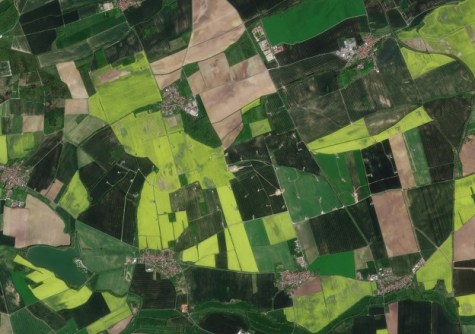
Syngenta, a global agriculture technology company, and Planet Labs have signed a new partnership deal that will give farmers access to near-daily satellite imagery.
The multi-year expansion of the companies’ strategic partnership will, they say, enable farmers to remotely monitor crop health, detect pest infestations and identify disease outbreaks.
The high-resolution, commercially available satellite imagery is to be delivered to farmers as part of Syngenta’s Cropwise digital agriculture platform.
Cropwise users will benefit from 3-metre resolution, daily capture satellite imagery of their farms from Planet’s Dove satellite constellation, providing frequent visibility and next level agronomic insights even in cloudy areas.
“This partnership will add a new dimension to Syngenta’s digital offering for customers”, said Jeremy Groeteke, Global Head of IT & Digital Strategy at Syngenta.
“We will build on top of its already popular remote sensing product set providing key solutions like Variability Index, Productivity Zones, NemaDigital, and Anomaly Detection”.
Syngenta will gain expanded access to Planet’s high-resolution tasking data, its PlanetScope near-daily satellite data and the Planet Insights Platform to build new applications for broad area management and enable novel research and development initiatives in precision agriculture.
“The challenges that farmers face today are complex, from pest infestations to drought,” said Feroz Sheikh, Chief Information and Digital Officer of Syngenta.
“We are building sophisticated AI and machine-learning algorithms to help farmers deal with this complexity.
“At the same time, we are committed to protecting farmers’ data rights, ensuring they maintain control over their information.”