Position Partners is pleased to announce the launch of its new survey grade Remotely Piloted Aircraft System (RPAS) bundles, which offer a seamless workflow solution for centimetre level accuracy at extremely cost effective prices.
Utilising revolutionary Propeller AeroPoint ground control technology for absolute coordinates and ultimate precision, along with Propeller Aero web-based data analysis and sharing tools, users can opt to use their existing RPAS or purchase a bundle solution from Position Partners’ range of industry-leading drones.
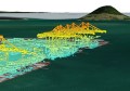
AeroPoints enable greater accuracy and efficiency for your aerial mapping applications, giving you faster access to your data and eliminating hand painted crosses on the ground.
The unique checkerboard design makes AeroPoints easily visible from the air, and with built-in GPS that can be cross referenced with Position Partners’ RTK network AllDayRTK, you are guaranteed precise results.
 With a simple one-button operation, capturing your project is as simple as laying out the AeroPoints, flying your RPAS, wirelessly sending your position information to the server as you collect your AeroPoints and then analysing your data using Propeller’s web-based platform.
The new Matrice 100, or M100, from DJI is a high performance aircraft with advanced in-flight stability, dual battery for longer flight times, and a host of other features that, when paired with AeroPoint ground control and Propeller software, make it a robust survey-grade system.
To find out more about Propeller AeroPoints and our start to finish survey grade RPAS bundles, visit http://www.positionpartners.com.au/start-to-finish-survey-solution.htm or call 1300 867 266 to speak to your local Position Partners team.