

In our regular Spatial Snippets feature, we bring you a round-up of all the bits and pieces of geospatial news that didn’t make it into our normal daily coverage.
Do you have a Spatial Snippet to share? Let us know by sending us an email.
C.R. Kennedy and Leica Geosystems are showcasing the Leica TS20 robotic total station at a series of launch events around Australia. According to Leica Geosystems, the TS20 features upgraded hardware, software and connectivity for a faster, quieter and more reliable experience in the field. From wireless communication and field and office software to theft deterrence and data sync, it’s fully connected and secured. Find your nearest launch event location.
Land Services SA has launched its new website, which, it says, offers easier access to documents, improved content structure, smarter tools, a mobile-friendly design and new navigation shortcuts. There’s also a chatbot called Robert.
Still with Land Services SA, the government body will hold a Survey Industry Event in Adelaide from 4:30pm to 6:30pm on 18 November, providing an opportunity for surveying industry professionals to network with their colleagues.
And still in South Australia and of interest for land surveyors, the Department of Housing and Urban Development has released reviewed and revised versions of the Guide to the Accredited Professionals Scheme, along with a Qualifications, skills and experience requirements for Accredited Professionals document, plus information about CPD.
Before You Dig Australia (BYDA) has announced the dates for its Utility Safety Conference. The event will take place on 4 and 5 March 2026 at the RACV Club in Melbourne. There will be sessions on digital transformation, risk management and best practice in underground safety, and a progress report on the BYDA Digital Utility Portal.
On the topic of events, early bird registration is now open for the Australasian Hydrographic Society’s international HydroSpatial 2026 conference, which will take place from 23 to 27 March 2026 in Wellington, New Zealand. The theme will be Shaping the Future of Marine Discovery, and the event will bring together experts from the disciplines of hydrography, oceanography, maritime heritage, environmental science, coastal development, defence and more.
Toitū Te Whenua Land Information New Zealand (LINZ) is offering scholarships of up to NZ$5,000 to help New Zealand students further their geospatial studies in 2026. Scholarships are available to cover undergraduate or postgraduate fees for GIS courses, or for research or other study-related expenses during the period of the scholarship. The application deadline is 30 November 2025.
The 2025 Pacific GIS & Remote Sensing User Conference will be held in Suva, Fiji, from 24 to 29 November. This is the largest annual GIS and remote sensing event held within the Pacific Island community, regularly bringing together more than 300 experts from government, academia and industry for five days of presentations and workshops. The conference is organised by the Pacific GIS and Remote Sensing Council.
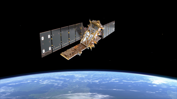
The Copernicus Sentinel-1D synthetic aperture radar (SAR) satellite is due for launch at 8:02am on the morning of 5 November, Australian Eastern Daylight Time. The European Space Agency will livestream the event, beginning at 7:15am. Sentinel-1D will join Sentinel-1C on orbit and replace the 11-year-old Sentinel-1A. Like it’s siblings, Sentinel-1D will have a sun-synchronous orbit at an altitude of about 700 kilometres, which will give it a 12-day repeat cycle.
The Open Geospatial Consortium (OGC) has published the SpatioTemporal Asset Catalog (STAC) Community Standards, a family of specifications that aims to standardise how geospatial asset metadata are structured and queried. A ‘spatiotemporal asset’ is any file that represents information about the Earth at a specific place and time. According to the OGC, STAC was initially designed for satellite imagery but has evolved to support other data resources and formats, including aircraft and drone imagery; hyperspectral, optical, and SAR data; video; point clouds; lidar; DEM; vector data; machine learning labels; and composites like NDVI and mosaics.
Finally, the team behind the bid for a Co-operative Research Centre (CRC) for precise and secure positioning, navigation and timing (PNT), known as SHIELD CRC, has been holding informative meet and greet workshop sessions around the country. The next ones will be in Adelaide on 17 November and in Perth on 19 November. SHIELD stands for Secure, Hardened, Integrity enhanced, Location and timing Defence.
Make sure you don’t miss out any geospatial news from across Australia and around the world — subscribe to our free Spatial Source newsletter, sent out on Wednesday and Friday mornings.


