

Geospatial tech company Aerometrex has developed a way to identify and measure living rooftop green spaces, green building facades, and a process to determine viable new rooftop garden and solar panel locations.
The latest data suite helps city councils meet their urban greening and cooling targets and implement more climate change mitigation activities with strong data backing.
Cities globally are learning how important the urban forest is for liveability and reducing the effects of climate change, and are exploring new ways to renew unused spaces.
Aerometrex’s new capability is ready to meet the Australian market and apply the base methodology to any 3D city dataset the company has captured.
This new data adds to Aerometrex’s Urban Forest Management Data Suite, which includes Urban Vegetation and Tree Canopy Reports, and Permeable and Impermeable Surface Mapping. Aerometrex’s full suite of services gives robust and repeatable data on urban climate change mitigation strategies.
![]()
Greening Melbourne
The City of Melbourne established the Green Our City Strategic Action Plan to set out the vision for increasing green infrastructure in the private realm as part of its response to address the effects of continued growth and urban densification.
The City of Melbourne is working with the development industry to expand urban greening, making available relevant data to the public, and introducing changes to the planning scheme for green cover requirements.
Aerometrex’s project outputs give relevant information and data improve greening outcomes in new buildings and developments. The datasets will act as a demonstration and research tool for other local and state governments, and industry to learn from.
Other benefits and future research that can follow from this project relate to humidity, aesthetics, noise reduction and local air quality improvement.
Aerometrex and the City of Melbourne are confident that the private sector, industry, policymakers and researchers are better-placed to make decisions around urban greening for new buildings and development.
Melbourne’s strategy puts it alongside cities around the globe, using the urban forest for climate change mitigation and increasing liveability, and Aerometrex is building measurement systems to support this strategy.
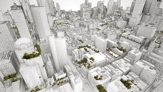
Measuring Melbourne’s green rooftops and facades
Aerometrex used 7 square kilometres of their 2013, 2017 and 2021 3D city models as the spatial data source. True ortho mosaics and digital surface models derived from the 3D models, and a combination of object-oriented imagery analysis and machine learning techniques were used to classify the surface cover into different categories. Final manual quality checks validated the data.
Aerometrex’s data measured an increase from 18,930 square metres in 2013 to 37,472 square metres in 2021 of living vegetation, with the total number of green rooftops increasing from 713 to 1081 in the same period. The number of green facades has risen from 25 to 63.
The City of Melbourne now has datasets to gauge their greening targets’ retroactive success and capacity to measure changes in future.

Finding future green rooftop spaces
Aerometrex developed more data outputs to identify sustainable locations for rooftop gardens using area solar radiation maps, slope maps, and aspect maps from the 3D model imagery overlaid onto building footprint data.
Solar insolation levels from the winter solstice, the lowest for the year, set the baseline sustainability measure for the potential rooftop green spaces. Adequate sunlight on the winter solstice, with the lowest solar insolation for the year, means the rooftop garden will survive year-round.
Why green buildings?
Rooftops and building facades are ideal greening spaces because of the high incident solar radiation levels that can sustain plants. Green building surfaces are a robust climate change mitigation strategy because they transform surfaces from heat sinks of reflecting light into a cooling space. Further, rooftop gardens absorb C02, filter storm water, and reduce a building’s use of air conditioning.
As the built environment grows, the options for planting and green spaces typically reduce. Green buildings re-claim some of what is lost in urban development.
Ready for Australian cities
Aerometrex’s methodology for measuring living green rooftop garden area and change over time and identifying potential rooftop garden locations is replicable in any Australian city with multiple existing 3D city models. Aerometrex’s years of 3D modelling program means Sydney, Brisbane, Adelaide and Perth are already candidates for the same Green Rooftop analysis and future planning.
The data outputs leverage Aerometrex’s diverse expertise across AI, change analysis derived from 2D and 3D imagery, and 3D visualisation. That combined skill set makes Aerometrex uniquely positioned for developing and delivering new use cases for its data and insights derived from its 2D ortho imagery, 3D models and LiDAR with full control of the process.
LEARN MORE: Go to www.aerometrex.com.au to learn more about Aerometrex’s services.
Information provided by Aerometrex


