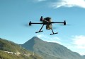
UAV innovators, Sentera, has just released its enhanced, affordable Phoenix fixed-wing drone product line. Specific product variants are designed to suit the precision agriculture, mapping, and public safety industries.
By pairing cutting-edge technologies with manufacturing efficiencies, Sentera’s Phoenix is a cost-effective solution that is easy to fly, accepts a variety of payloads, and covers more acres in less time than competitive options. With the complete solution with payload starting at US$10,990, Sentera claim the light-weight, highly durable Phoenix is the best valued fixed-wing drone on the market today.
“Our customers depend on us to provide user-friendly drone solutions to collect the data they need at a price that makes sense,” remarked Todd Colten, chief aerospace engineer for Sentera. “The Phoenix is a complete professional solution for the quick collection of highly accurate and detailed data – from crop health, to volumetric measurements, to search and rescue operations.”
At only four pounds with an oversized motor, the Phoenix is easily hand-launched. With up to an hour of flight time at 35 mph speeds and up to a 59-minute endurance, Phoenix covers large areas quickly.
“Agronomists, crop consultants, and growers fly their fields multiple times throughout a growing season, looking for comparative data,” commented Colten. “The Phoenix is a great solution for these crop scouting missions since it can be programmed to fly the exact same pattern multiple times, ensuring data comparability.”
The small, light drone is the next generation of the proven Sentera Phoenix fixed-wing platform. To optimize industry solutions, Sentera developed three distinct Phoenix variants:
- Phoenix Pro: Ideal for precision agriculture and mapping activities
- Phoenix MS: Perfect for advanced volumetric readings
- Phoenix LE: Designed for public safety missions
The Phoenix offers users the highest sensor and mission versatility available, accepting multiple swappable sensors, including the Sentera Double 4K Sensor, providing true RGB and normalized difference vegetation index (NDVI) data, in a single flight. The Sentera Quad Sensor, a multispectral imager with red edge capabilities is also popular in agriculture applications. The Sentera Thermal also sensor which quickly builds high-resolution true temperature maps.