


You’re invited to join an Earth Observation Dashboard Hackathon to help solve COVID-19-related challenges.
Search results for "nasa"

SmartSat CRC appoints NASA engineer as CRO
Dr Carl Seubert will help guide SmartSat CRC’s federally funded $245m research and development investment program.
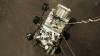
NASA video lets you join Perseverance on Mars
The video from NASA’s Perseverance rover chronicles the final minutes of its entry, descent, and landing.

Australia signs NASA’s Artemis Accords
Australia becomes one of the first signatories to NASA’s new collaborative agreement.

The ‘Pale Blue Dot’ revisited by NASA
A recent update to this historic portrait shows Earth as a tiny speck in the vastness of space.
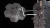
NASA to trial in-space manufacturing
NASA has contracted Maxar to robotically manufacture an antenna and spacecraft beam in orbit.
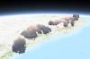
NASA releases 3D view of Australia’s bushfire smoke
The Bureau of Meteorology is using the map to improve air quality forecasts.

NASA survey of Antarctic ice launches from Hobart
NASA’s Operation Icebridge will be the largest survey of Earth’s changing sea ice ever taken.

UNSW harnesses Google and NASA data for ecosystem mapping app
REMAP enables simple and swift analysis of Landsat data for ecosystem monitoring.

NASA’s push to drive commercial data use
Release of remote sensing toolkit aimed at driving commercial uptake of NASA-produced Earth Observation data.
