

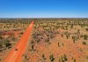
A milestone has been reached in the NT’s Regional Ecosystem and Landscape Mapping program.
Search results for "asset management"
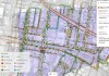
Transforming underground utility location data
A BYDA trial tested whether diverse utility data can be visualised clearly on a single GIS platform.
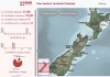
NZ’s online landslides map will be vastly expanded
The number of records in the New Zealand Landslide Database will jump from 23,000 to more than 500,000.

Spatial Snippets for Friday, 31 October 2026
Enjoy our new weekly compilation of geospatial news bites from across Australia and around the world.

Save the date: Spatial WA program update webinar
Hear from the program’s leaders and find out how Spatial WA is already being applied in real-world settings.
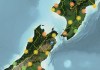
Free mapping data enables vital pest control
LINZ Basemaps data is being used to help control pest species and improve native habitats across New Zealand.

Q&A with Zaffar Sadiq Mohamed-Ghouse
Combatting climate change, saving lives and building better societies are top of mind for Dr Zaffar Mohamed-Ghouse.

Interview: Gaye Searancke, Chief Executive, LINZ
In this exclusive interview, we find out more about Land Information New Zealand and its activities.

Victoria’s vision for a modern cadastral system
With a 10-year strategy well underway, Victoria is on track to deliver a land administration system for the 21st century.

Terria targets the digital twin universe
We speak with the firm’s co-founders to find about more about its aim of making digital twins accessible to all.