

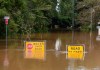
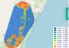
Geospatial, socioeconomic and property data reveal the inequalities faced by flood-prone communities.
Search results for "AURIN"

Join the Missing Maps Map Party in Melbourne
The Planning Institute of Australia event will boost skills for helping disaster-prone areas that lack reliable maps.
Spatial Snippets for Wednesday, 4 December 2024
Check out our regular compilation of geospatial news snippets from across Australia and around the world.
Supporting critical research with geospatial data
Geospatial research and analysis are critical in providing the evidence base required for policy and planning.
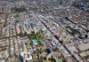
Spatial data at heart of housing analytics lab
The new UNSW-based lab will provide evidence-driven solutions to national housing problems.

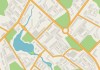
Noise models meet geospatial for urban planning
Ambient Maps and AURIN to bring advanced noise modelling and spatial intelligence to urban planning.

Giant of Australia’s geospatial sector passes away
Dr Peter Woodgate, President of the newly formed Geospatial Council of Australia, has passed away.

Locate20 to focus on global challenges
Organisers say 2020 conference to emphasise spatial tech’s role in meeting immediate global challenges.

20 minute cities: unpacking the panacea
Investigating the concept underpinning planning during Australia’s urban population boom.

Q&A with Peter Woodgate
Peter Woodgate, chair of the Australian Urban Research Infrastructure Network, sits down for a one-on-one chat with Spatial Source.