

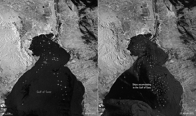
Traffic backing up in the Gulf of Suez. Contains modified Copernicus Sentinel data (2021), processed by ESA, CC BY-SA 3.0 IGO.
Radar images from the European Space Agency’s (ESA) Sentinel-1 earth-monitoring mission show shipping backing up in the Gulf of Suez as a result of the Ever Given container ship becoming stuck in the Suez Canal.
The ship ran aground on 23 March on its journey northward through the Canal.
The images above show the view on 21 March (left), with a normal level on traffic manoeuvring in the Gulf of Suez near the southern entrance to the Canal. The image on the right, taken on 25 March, shows the Ever Given stuck in the Canal and shipping beginning to back up.
The Sentinel-1A satellite was launched in 2014, with Sentinel-1B following in 2016. The twin satellites orbit Earth in the same plane and use C-band synthetic-aperture radar to provide all-weather, night and day coverage of the planet.
There are multiple satellites in the Sentinel series, designed to conduct remote sensing at various wavelengths. The latest, Sentinel-6A, launched in November 2020, is a radar altimetry mission primarily intended for monitoring the oceans.
Stay up to date by getting stories like this delivered to your inbox.
Sign up to receive our free weekly Spatial Source newsletter.


