

The Ordnance Survey (OS) has launched new data, including significant enhancements, in the OS National Geographic Database (NGD), covering transport and buildings across the UK.
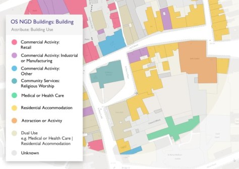
Building data has been significantly enhanced, including a new building geometry representing the building footprint, making it easier to select and analyse individual properties.
Additional attribute enhancements include providing the building use (eg commercial, retail or residential), connectivity to other buildings (for example whether a property is standalone or semi-connected), identifying a primary building within a site (such as a central hospital building with other clinics on site) and also providing the number of addresses which reside within the building (including how many are residential and commercial).
OS has also increased its coverage of Great Britain’s path network, now capturing data for the whole of England, Scotland and Wales, whereas previously only urban areas were captured. This work has resulted in over 10 million new path features which equates to an increase of almost 35%.
The enhancements enable further analysis to be undertaken on how pedestrians complete routes using both the road and path network, supporting travel policies, improvements to public health and projects to encourage walking.
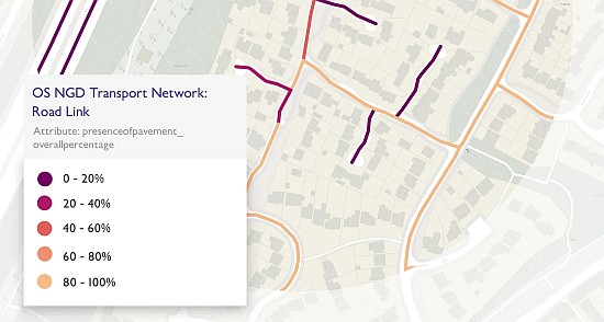
Another significant update means that for the first time, pavement (footpath) width and their presence along roads are now available as additional attributions. This will benefit analysis relating to those who use mobility scooters, wheelchairs or pushchairs.
The final update is the creation of a new generalised Rail Network for Great Britain, the first of its kind to be released by Ordnance Survey. This will enable customers to understand how well-connected areas are in relation to rail, including the transportation of goods, as well as improving situational awareness for emergency services when attending emergencies on the rail network.
All the new data enhancements have been released in the OS NGD, which is available to public sector customers and OS Partners through the OS Data Hub.
“This latest data release is yet another demonstration of the value of OS as the country’s national mapping service, providing incredibly detailed and accurate layers of geospatial data,” said John Kimmance, Managing Director of OS National Mapping Services.
“I am looking forward to seeing how these datasets will ultimately help people see a better place.”


