Image courtesy OGC
The Open Geospatial Consortium (OGC) is seeking public comment on an updated version (v1.1) of the CityJSON Community Standard.
The proposed update contains significant improvements over v1.0, including support for the OGC CityGML data model version 3.0 and support for handling large CityJSON files through streaming.
Comments are due by September 9, 2022.
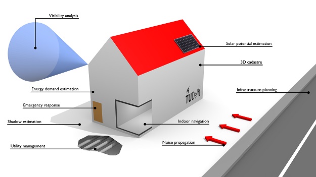
CityJSON defines ways to describe, in a JSON encoding, most of the common 3D features and objects found in cities (such as buildings, roads, rivers, bridges, vegetation, and city furniture) and the relationships between them.
It also defines how to encode different standard levels of detail (LoDs) for the 3D objects in JSON, which enables users to represent different resolutions of objects for different applications and purposes.
The aim of CityJSON is to offer an alternative to the GML encoding of CityGML, which can be verbose and therefore complex to work with. CityJSON aims at being easy-to-use, both for reading datasets, and for creating them.
CityJSON was designed with programmers in mind, so that tools and APIs supporting it can be quickly built. It was also designed to be compact, typically compressing publicly available CityGML files by 6x.
A CityJSON file describes both the geometry and the semantics of the city features of a given area. A CityJSON object, representing a city, is as ‘flat’ as possible, i.e., the hierarchy of CityGML has been flattened out and only the city objects which are ‘leaves’ of this hierarchy are implemented.
This considerably simplifies the storage of a city model, and furthermore does not mean that information is lost.
CityJSON v1.0 was accepted as an OGC Community standard in August 2021. CityJSON version 1.0 is a JSON-based encoding for a subset of the OGC CityGML data model version 2.0.0.
The CityJSON v1.1 Community Standard Justification Document outlining the many changes is available for review and comment on the OGC Portal. The complete CityJSON v1.1 specifications are available on the CityJSON website.
Comments are due by September 9, 2022, and should be submitted via the method outlined on the CityJSON v1.1 Community Standard’s public comment request page.
Stay up to date by getting stories like this delivered to your inbox.
Sign up to receive our free weekly Spatial Source newsletter.