

New Zealand’s navy will no longer carry out underwater mapping work for non-military purposes under new cost-cutting measures.
In a major review of military capability, defence chiefs have been told to find up to NZ $400 m worth of savings to redirect into combat capability.
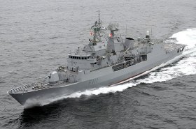
The navy had been working with Land Information New Zealand doing hydrographic surveying to map the sea floor, but according to the review will scrap one of two ships currently used for diving, mine counter measures and hydrographic work.
“The [remaining] new ship will consolidate a number of linked capabilities, and will have the speed to provide timely support to operations. Hydrographic work, which is currently conducted by both the Navy and the National Institute of Water and Atmospheric Research (NIWA), will be rationalised,” says the report.
Land Information New Zealand said it will go to the open market to secure contracts for the surveys it needs to gather official data for navigation safety.
The National Institute of Water and Atmospheric Research said it has the capacity to take on more underwater mapping work when the navy pulls out.
NIWA's general manager for research, Rob Murdoch, said the organisation already does deep-sea surveying for Land Information and could easily pick up more work.


