The University of Queensland has played a key role in a “paradigm shift in how hyperspectral data can be acquired” via aerial imaging.
Geoscience and remote sensing researchers from UQ’s Sustainable Minerals Institute (SMI) have taken part in a European-led consortium called ‘m4mining’ that delivered a hyperspectral aerial imaging system.
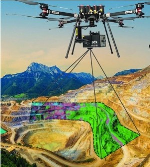
The system is capable of mapping surface patterns of minerals, soils and plants in real time, potentially greatly aiding exploration and mining activities.
The European Union has acclaimed it as a gamechanger for mineral exploration.
Aerial imaging for faster decision-making
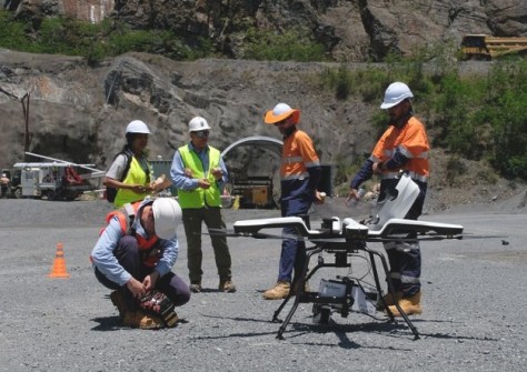
The drone-mounted imaging system harnessed remote sensing technology and complex physics to provide users with a near-instant 3D mesh of a survey area.
Importantly, the data gives clues as to what might lay underground.
“SMI was recruited to provide the consortium with a bridge to the resources industry and to interpret data captured during case studies in regional Queensland before a final validation flight in Brisbane,” said Associate Professor Steve Micklethwaite, leader of the UQ Drone Collaborative Research Platform.
“We confirmed the processing power of the Norwegian-engineered technology allowed for near-immediate access to complex aerial mapping data, instead of users having to wait weeks or even months to see results.”
Dr Micklethwaite said hyperspectral image processors have been used on drones before but processing the data post-mission had taken “a deceptively long time”.
“With this system, data you capture comes in a useable format when the machine touches down,” he said.
“It is real-time processing that allows users to make fast, informed decisions about their projects.”
A paradigm shift for the mining industry
The m4mining consortium was provided with $7.3 million (€4.5 million) seed funding from Horizon Europe. The goal was to demonstrate a system that could boost material characterisation during exploration, extraction, re-mining and environmental impact monitoring.
The consortium is led by Norwegian research centre NORCE and imaging company Norsk Elektro Optikk AS, which produces technology under the HySpex brand.
Dr Micklethwaite said it was SMI’s reputation for industry-facing research and its existing relationship with HySpex that were key to UQ being invited into the consortium.
“This meant establishing a minerals advisory board within the project and receiving feedback from industry during the development of the technology to make changes and improvements where needed,” he said.
In its general review of the m4mining project, evaluators for the European Commission lauded the group for delivering a fully integrated, validated, and market-ready technological solution for the mining industry.
“The final result represents a paradigm shift in how hyperspectral data can be acquired, processed, and utilised in complex mining environments,” the report reads.
Plans for linking aerial and satellite data
HySpex has since integrated the m4mining technology into a commercial hyperspectral imaging product called BiFrost that it plans to publicly launch in the coming months.
NORCE project management lead Edmond Hansen praised the SMI collaborators for helping achieve the aerial imaging breakthrough.
“Such technological development would not have been possible without cross-border collaboration and strong partnerships between industry and academia, in which UQ played a central role,” he said.
“Australia’s forthcoming participation in European research funding programs presents excellent opportunities for further collaboration and joint technological advancement.”
According to Professor Micklethwaite, the SMI team is already developing methods to link drone hyperspectral data with satellite data to improve the resolution and fidelity of the satellite data.