NASA’s Earth Science Data Systems service has released a tutorial that shows an easier way to find Harmonised Landsat and Sentinel-2 (HLS) imagery.
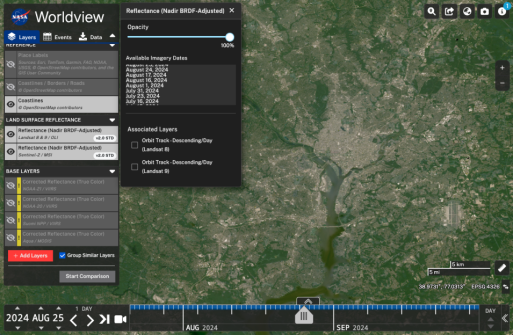
HLS imagery is now more accessible thanks to the new ‘Available Imagery Dates’ selector in NASA Worldview.
According to NASA, 30-metre resolution HLS imagery has been available in Worldview since 2021 as two Nadir Bidirectional Reflectance Distribution Function (BRDF)-Adjusted Reflectance layers: one from the Operational Land Imager (OLI) aboard the Landsat 8 and Landsat 9 platforms, and the other from the Multi-Spectral Instrument (MSI) aboard the ESA Sentinel-2A, Sentinel-2B, and Sentinel-2C platforms.
Due to the high spatial resolution of the imagery, the swath width is narrower and the temporal resolution is lower for OLI and MSI than for the Moderate Resolution Imaging Spectroradiometer (MODIS) or the Visible Infrared Imaging Radiometer Suite (VIIRS).
As a result, there won’t be daily, high-resolution images across the globe, and users might not find an image for the area they are looking at on a particular day.
But with Worldview’s Available Imagery Dates option, if a user is zoomed into a particular part of the world and would like to see when HLS imagery is available, they can open the ‘Options’ panel and select a date from the Available Imagery Dates list. This will enable the user to find dates that have imagery for that area of interest.
The following video provides a demonstration of the function.