

A new imagery layer has been added to NASA’s Fire Information for Resource Management System (FIRMS).
FIRMS is a well-known and widely used service for helping users to identify the location, extent and intensity of fire activity.
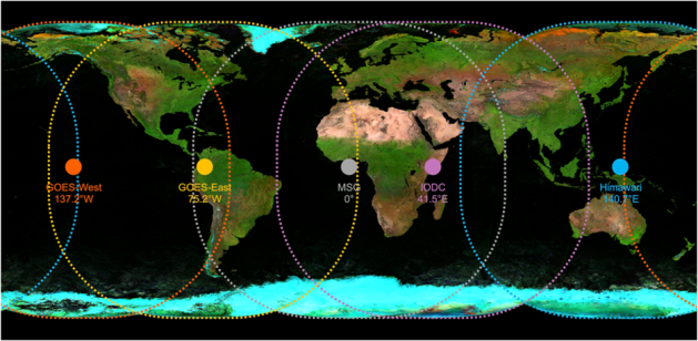
The new Geostationary Ring Natural Colour RGB imagery layer, provided by EUMETSAT, is a mosaic of RGB natural colour imagery derived from instruments aboard five geostationary satellites.
Together, the satellites provide complete worldwide coverage:
- GOES-18 (GOES West) / Advanced Baseline Imager (ABI), at 137.2º W (labelled GOES West in FIRMS)
- GOES-19 (GOES East) / ABI, at 75.2º W (labelled GOES East)
- Himawari-9 / Advanced Himawari Imager (AHI), at 140º E (labelled Himawari-9)
- Meteosat Indian Ocean Data Coverage (IODC) / SEVIRI, at 45.5º E (labelled MSG IODC)
- Meteosat 0 Degree / Spinning Enhanced Visible and Infrared Imager (SEVIRI), at 0º (labelled MSG 0 deg)
Australia is covered by Himawari-9, IODC and GOES-West.
Although the instruments take images at 10- to 15-minute intervals, the layer is updated every 3 hours. This frequency still provides essential coverage for filling in the gaps from polar-orbiting satellites that have long revisit times.
The false-colour composite layer assigns red, green and blue display channels to the short-wave infrared, near infrared and red reflectance bands for each instrument.
The resulting imagery typically results in features with the following characteristics:
- Healthy vegetation (green)
- Burn scars (reddish-brown)
- Bare soils/deserts (brown)
- Clouds (white)
- Smoke (white, grey or light brown)
- Snow and ice (cyan)
- Deep water bodies (dark blue)
- Shallower water bodies (light blue)
The Worldview interactive visualisation tool also features the Geostationary Ring Natural Colour RGB imagery layer, plus other Geostationary Ring imagery layers.
Worldview provides access to various imagery layers from EUMETSAT data: Air mass, volcanic ash, dust, and infrared 10.8 μm. These data are based on infrared channels and are made available at 3-hour intervals.


