PARTNER FEATURE
Global Mapper Pro®, the all-in-one geospatial software tool from Blue Marble Geographics® recently debuted version 26.0 with exciting new features driven by collaboration and insights from our users.
This version of Global Mapper pushes forward with updates to the machine-learning-based automatic point cloud analysis and adds deep learning image analysis in the new Global Mapper Insight and Learning Engine™ (beta), which is now available for beta testing in Global Mapper Pro 26.0.
Complete point cloud analysis workflows in Global Mapper Pro
Starting with a raw LiDAR point cloud or a set of drone/UAV-collected images, Global Mapper Pro can take workflows from start to finish with its wide array of tools. The Pixels to Points® photogrammetric tool processes drone/UAV-collected images to create seamless 3D data outputs from a set of overlapping images.
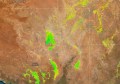
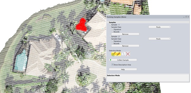
Point cloud classification in Global Mapper Pro uses an advanced, segmentation-based method to automatically identify basic classes such as ground, buildings, vegetation, powerlines and poles. To extract even more information from a 3D point cloud, Global Mapper Pro provides a cutting-edge machine-learning tool for the building of custom point cloud classifications. By collecting samples of a specific feature type in a point cloud, a class signature is built and can then be saved, shared and used to identify custom features.
This functionality available in Global Mapper Pro is already in use across industries on large and small scales, with objects such as airplanes, cars, paint lines on asphalt, bridge structural components and more being identified and classified from raw LiDAR data.
Working in combination all within a single program, the advanced point cloud tools in Global Mapper Pro enable users to load data from multiple sources and process it into classified datasets and terrain surfaces, ready for further analysis.
Incorporate raster data with advanced image analysis
Moving from 3D data analysis into 2D raster image analysis, perhaps the largest addition to Global Mapper Pro v26.0 is the Insight and Learning Engine, a new module featuring deep learning-based image analysis. The Insight and Learning Engine provides advanced object detection and land cover classification models. With built-in models for vehicle detection, building extraction and land cover classification, the Insight and Learning Engine extracts vital information from high-resolution imagery.
Image analysis inherently has many variables to account for — date of acquisition, sensor type, cloud cover and other environmental factors, along with many other factors, can all impact an image. The Insight and Learning Engine addresses this with a fine-tuning tool. By utilising data markup tools in Global Mapper Pro, the fine-tuning interface in the Insight and Learning Engine enables users to create ground-truth data.
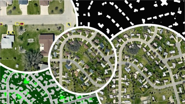
Existing models can be iteratively fine-tuned or fully re-trained to produce better classification and object detection results. Fine-tuned models are then saved in-app, allowing users to reuse them again and again, or continue fine-tuning with additional datasets.
Going beyond fine-tuning, which allows a user to control how deeply a model is adjusted, the Insight and Learning Engine allows users to conduct a full training. This may be necessary when training data is differs enough from data for which the models are best suited that initial inference results are less than ideal. This is accomplished with user provided imagery and corresponding ground truth. The results of this process, in addition to those of fine-tuning, can then be saved or further trained with goals of accurately identifying custom classes from loaded imagery.
Adding the Insight and Learning Engine to the suite of Global Mapper tools increases the depth of functionality in the program and broadens the advanced analysis techniques from point cloud data to raster image classification. Combining these significant machine learning tools with all the other updates and improvements in Global Mapper Pro 26.0, such as solar shadow analysis, improvements to the Pixels to Points drone/UAV toolset and extra LiDAR attribute handling, to make the program a powerful choice for geospatial software.
With these expansions to functionality available in Global Mapper Pro v26.0 make the program an invaluable geospatial data creation and analysis tool across many diverse industries.
Learn more about what you can do with Global Mapper Pro at bluemarblegeo.com.
Important note: The new Insight and Learning Engine (beta) in Global Mapper Pro v26.0 is available to all users with active Maintenance and Support. It requires version 26.0 to be installed and licensed. Users who wish to continue the use of the Insight and Learning Engine in Global Mapper Pro v26.1 will need to install that update when it is released in the first half of 2025. These tools will remain available to Pro users in Global Mapper Pro v26.1 until September 2025.