The International Cartographic Association is on a mission to support cartographic R&D, education and knowledge dissemination.
By Amy Griffin
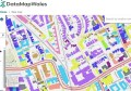
Leafing through the pages of any issue of Position magazine will illustrate how fundamental maps and geospatial visualisations are to the practice of surveying and geospatial science. Whether they are used to communicate the results of a complex spatial analytical workflow, to understand the location of a resurveyed boundary in relation to historical surveys of the area, or to depict the potential impacts on a location of developing a new piece of infrastructure within a spatial digital twin, maps and visualisations help us to understand the world.
Maps influence both our thinking and our behaviour, and successful maps help their readers to solve problems and understand environments.
The peak international body that supports the development and practice of mapmaking is the International Cartographic Association (ICA: icaci.org). The ICA was founded in 1959 in Switzerland with 13 members and since that time its membership has grown to include 74 countries. It welcomes participation from anyone with an interest in maps, including government mapping agencies, researchers, private companies, educators, map enthusiasts and software developers. It has as its aim “the promotion of the disciplines and professions of cartography and GIScience in an international context”.
The ICA is an organisation of organisations — something like the United Nations for cartography, its primary members are national members. These national members represent the interests of mapmakers from that country at the ICA every four years at a special meeting called the General Assembly, which takes place during the International Cartographic Conference. Each national member is entitled to send one delegate to the General Assembly.
National members are typically national cartographic, geographical information associations or national institutions such as national mapping agencies. In the Australasian region, the national members include the Mapping Sciences Institute of Australia (joined 1964), the New Zealand Cartographic Society (joined 1976) and Badan Informasi Geospasial (the Indonesian Geospatial Information Agency, joined 1980 when it was formerly called Bakosurtanal).
The ICA also welcomes affiliate members, which may include organisations, companies or institutions whose membership supports the ICA’s activities and mission. In the Australasian region, affiliate members include the Australian and New Zealand Map Society and Toitū Te Whenua Land Information New Zealand.
What does the ICA do?
The ICA undertakes several types of activities, including:
- Supporting cartographic research and development.
- Building capacity in and transferring cartographic knowledge to countries with limited mapping expertise.
- Promoting cartographic and geospatial scientific education.
- Maintaining authoritative repositories of cartographic knowledge.
- Participating in the development of professional and technical standards, including with other organisations such as the Open Geospatial Consortium and the International Standards Organisation.
- Hosting international meetings and cartographic exhibitions, such as the biennial International Cartographic Conference, to share cartographic expertise.
- Providing fora for disseminating cartographic knowledge, such as the ICA News or eCartoNews, and scientific publications such as the Proceedings of the ICA and the International Journal of Cartography.
- Offering cartographic expertise to international organisations such as the United Nations, including to the UN Committee of Experts on Global Geospatial Information Management.
- Membership in and cooperation with related organisations and sister societies (e.g. International Science Council, Open Geospatial Consortium, International Society of Photogrammetry and Remote Sensing, International Federation of Surveyors, International Geographical Union, International Hydrographic Organization, International Map Industry Association).
The people and products of the ICA
The work of the ICA is undertaken by the Executive Committee and the Chairs of Commissions and Working Groups. Members of the Executive Committee and Commission and Working Group Chairs are nominated by their national member and elected or approved by the General Assembly. Each of the ICA member countries within the Australasian region have participated in the executive leadership of the ICA. Australia and Indonesia have had several Vice Presidents (Australia: B.E. Goodrick, William Cartwright, Amy Griffin; Indonesia: Sukendra Martha), while Igor Drecki from New Zealand was the long-standing ICA News Editor until his untimely passing in 2023. Cartographers from the Australasian region, too numerous to list individually, have also been Commission and Working Group chairs.
The research and development work of the ICA is undertaken by the Commissions and Working Groups. Commissions are composed of cartographers from any sphere (government, industry, universities) who come together to investigate specific problems related to the Commission’s theme. Some examples of current commissions include Art & Cartography, Atlases, Cartography & Sustainable Development, Cartography in Early Warning and Crisis Management, Ethics in Cartography, GeoAI, Geovisualisation, Location-based Services, Map Design, Map Projections, Marine Cartography, Topographic Mapping, and User Experience, among others.
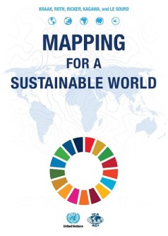
This work happens both online and offline and results in a range of products, including scientific publications, education and training materials, workshops, and books about cartographic best practices. One publication that you might be interested to explore and that is freely available online is a joint publication produced by the ICA and the United Nations, a book on mapping best practices entitled Mapping for a Sustainable World (available as a downloadable PDF). This book uses data measuring progress towards the Sustainable Development Goals to explain and illustrate cartographic best practices.
Find out more
In future articles, we will profile some of the ongoing projects being undertaken by ICA Commissions. ICA also has biannual print and monthly electronic newsletters and the eCarto News publication (edited by retired RMIT University professor David Fraser), which compiles information about interesting maps and mapping developments.
The ICA website includes information about the structure of the organisation, upcoming and past International Cartographic Conferences, and links to Commission webpages where you can find out more about the work of specific commissions.
If you’re interested in getting involved in ICA, you can contact relevant Commission Chairs directly, or send me a message (amy.griffin@rmit.edu.au), and I’ll help you find the right person to speak with.
Amy Griffin is a Senior Lecturer in Geospatial Sciences at RMIT University, and current ICA Vice President.
This article was first published in Issue 129 (Feb/Mar 2024) of Position magazine. Please consider subscribing.