Immune to magnetic disturbances and calibration-free – no need to level
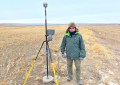
Introducing the world’s fastest and easiest-to-use GNSS RTK rover, the Leica GS18 T. Now you can measure any point faster and easier without the need to hold the pole vertical.

This latest innovation combines GNSS and inertial measurement unit (IMU) being the first true tilt compensation solution that is immune to magnetic disturbances and is calibration-free. The GS18 T works directly out of the box and saves up to 20 per cent over conventional surveying practices since no time is wasted levelling the bubble.
Focus on your surroundings and not the bubble to measure points that previously could not be measured. Avoid time consuming auxiliary methods with true tilt compensated surveying. You will stake out more efficiently and conveniently than ever before with increased speed, safety and comfort. Watching the bubble is simply no longer needed.
The GS18 T GNSS RTK rover is part of the Leica Geosystems self-learning GNSS series. It seamlessly combines with Leica Captivate field software and Leica Infinity office software, continuing the powerful and immersive Leica Captivate Experience.
Engaging software
The GS18 T RTK rover combines seamlessly with the Leica Captivate software for a powerfully immersive experience. Through the simplicity of touch, management of complex data is made extraordinarily enjoyable and actionable. Leica Captivate spans industries and applications with little more than a simple swipe, regardless of whether you work with GNSS, total stations or both.
Infinite possibilities
While Captivate captures and models data in the field, Leica Infinity software processes the information back in the office. A smooth data transfer ensures the project stays on track. Captivate and Infinity work in conjunction to join previous survey data and edit projects faster and more efficiently.
With integrated quality assurance, this GNSS RTK rover records how the pole was levelled during the measurement and stores the values, ensuring measurement traceability and complete quality reporting.
Powerful handheld devices
In a controller or tablet, take your entire office on the go when you discover the power to overcome any environment from the palm of your hand. The Leica CS20 controller and Leica CS35 tablet provide the ultimate in control and convenience with complete mobility. Touchscreen technology allows for comfortable and quick data processing while a stunning 3D view transforms your GNSS experience.
Learn more at www.leica-geosystems.com/gs18t.