

Perth-based Earth observation company, LatConnect60, has selected Spire Global to provide GNSS reflectometry (GNSS-R) data and soil moisture insights.
The deal will see LatConnect60 combine its satellite-based optical and SWIR imagery with Spire’s soil moisture insights and GNSS-R data.
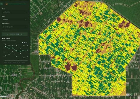
The information will be made available through LatConnect60’s web-based platforms to provide information on water management, usage efficiency and crop stress levels for users across Southeast Asia and Australia.
“LatConnect 60 looks forward to working closely with Spire to make this combined capability easily accessible to our end users across the Southeast Asian and Australian continents,” said Venkat Pillay, CEO and Founder of LatConnect60.
“We envisage tremendous demand for the insights that will be made available, particularly in agricultural or forestry areas that are not easily accessible for manual data collection, while leveraging the ability for the GNSS-R data to enable daily soil moisture readings even in heavy cloud cover and dense canopy environments.”
Spire uses its GNSS-R satellite constellation to deliver worldwide soil moisture insights at 500-metre and six-kilometre resolutions.
“Predicting biomass growth and understanding soil moisture conditions are essential for building climate resilience,” said Michael Eilts, General Manager of Weather and Climate at Spire Global.
“By combining our GNSS-R technology with LatConnect60’s analytical platforms, we are setting new benchmarks for accuracy in soil moisture data and comprehensive environmental monitoring in any corner of the globe.”


