

Shanghai will encourage the use of a highly accurate indoor mapping and positioning service based on Wi-Fi in big public buildings, to help people find emergency exits and help firefighters find people in need of rescue during fires.
Consumers who install the system on their smartphones or tablet computers will also be able to quickly find shops, according to officials from the Shanghai Technology Innovation Strategic Alliance of Satellite Navigation and Positioning Industries.
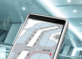
The system, accurate to within 3 to 5 meters, is under construction at two downtown trial spots – Raffles City and the Oriental Department Store.
While outdoor positioning services are common through global positioning system, or GPS, Shanghai is kicking off its indoor pilot program using Wi-Fi for positioning using devices such as smartphones.
“A wide-scale installation of Wi-Fi is the basis for such service,” said Lu Xinghai, secretary general of alliance. “We want to implement a smooth connection of outdoor and indoor positioning for the public.”
Shanghai Telecom officials said the company is working on indoor maps of business buildings, stores and malls.
“The system can greatly strengthen safety management,” said Luo Zhiyong, of Shanghai Telecom’s chief engineer’s office.
“If there is a fire, we have a background platform to guide rescue routes according to people’s position and tell firefighters where people are located,” Luo said.
The system is expected to be free for the public, while it can make a profit by allowing stores and shops to buy advertisements.
For outside positioning services, officials said the nation is promoting the civil use of the Beidou system, China’s own version of GPS, which has been introduced in national defence, communications, state grids and national safety plans.


