


Image credit: ©stock.adobe.com/au/Jandrie Lombard
To increase the confidence in, and usefulness of spatial cadastre data, the Intergovernmental Committee on Surveying and Mapping (ICSM) has produced a Standard for the Accuracy of Spatial Cadastres in Australia and New Zealand, along with a Supporting Document.
The Standard establishes targets and a reporting framework for acceptable Positional Uncertainty (PU) for the horizontal position of parcels within spatial cadastres.
The Standard requires PU to be attributed to points, lines and/or polygons within the spatial cadastre. The target PU for parcels in central business districts is 0.05m; urban, peri-urban and industrial areas 0.2m; rural areas 0.5m; and pastoral and remote areas 5m.
The images below illustrate the effects of improving the spatial accuracy of a spatial cadastre.
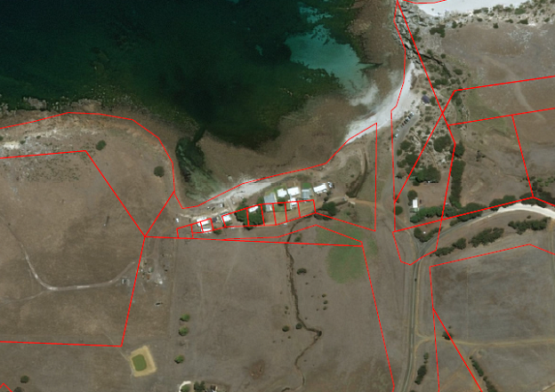
Stokes Bay, South Australia, before spatial upgrade.

Stokes Bay, South Australia, after spatial upgrade.
Vertical uncertainty of the spatial cadastre is not included in the Standard at present. As spatial cadastres evolve to meet the requirements of the Cadastre 2034 vision, recommendations for vertical uncertainty will be considered by ICSM.
This means that jurisdictions now have a reporting framework and accuracy targets to achieve to ensure their spatial cadastres meet the requirements of the Standard.
Improved spatial cadastres do not provide a legal position of the location of boundaries; they are still considered a graphical representation of the boundaries using the best available survey data and control.
The PU attribution cannot be relied upon for critical decisions and does not replace the need for a Licensed or Registered Land Surveyor to carry out a field survey for boundary reinstatement, and consideration of common law principles.
Bradley Slape, Surveyor-General of South Australia and Chair of the ICSM Cadastre Working Group, will launch the Standard at the Locate23 Conference in Adelaide, 10–12 May.


