The use of drone-based LiDAR has become progressively more common in land surveying over the past few years. As with all new technologies, there has been (and continues to be) a phased adoption to see integration with existing workflows and development of new workflows to see that the outputs are maximally fit for use.
Regional surveyors have a huge opportunity to leverage the value of drone LiDAR for topographic and land surveys. The benefits are well understood and marketed: increase efficiency, better detail, and improve the bottom line. However, with the cost of equipment significant and, often, the cost of training staff in data acquisition and post-processing underestimated, the implementation of drone LiDAR for regional firms and smaller teams has been difficult.
To unlock the value of drone LiDAR, it is worthwhile engaging a specialist spatial firm with established capabilities in data acquisition and post-processing. Diospatial has been at the forefront of bringing this technology to the engineering and surveying sector and specialises in providing high accuracy and high-resolution LiDAR surveys. The firm is regularly engaged by registered surveyors and engineers throughout New South Wales, Victoria, and Queensland to provide point cloud and derived data products in ready to use formats.
“The key to delivering real value with drone LiDAR lies not in the drone or the LiDAR sensor but through delivering fit for use spatial data to the client – for us that means the right data in the right format, backed by stringent quality control and metadata.”
Zack Wasson – Managing Director of Diospatial
USEABLE DATA
Regional surveyors are presented with some unique challenges. Regional sites are often large parcels of land, across rugged terrain, with hard to access features including thick vegetation and rugged topography. Aerial imagery and point cloud or DEM data is usually available through open sources, however this data is often outdated and lacks the necessary resolution and accuracy required for surveying, engineering, and town planning purposes.
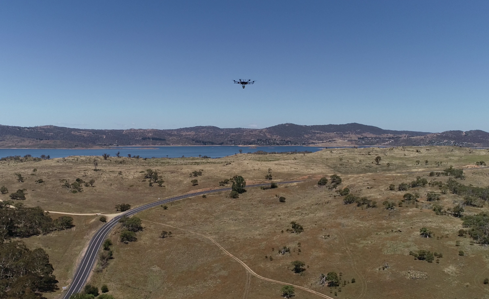
Drone LiDAR not only improves access to difficult terrain, but it also captures data at a very high resolution in a fraction of the time and cost. LiDAR can penetrate even dense vegetation, capturing the landform detail in areas otherwise inaccessible or poorly defined by conventional or other means. High resolution imagery can be captured at the same time to produce an orthophoto and textured mesh model for visualisation and context.
But more detail doesn’t necessarily mean better outcomes. Often it leads to more confusion and frustration. This is where the post-processing workflows and capabilities of specialist firms like Diospatial provide significant value.
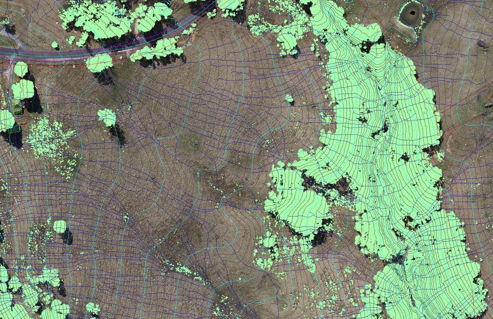
Diospatial classifies the LiDAR point cloud data, filters out the noise, parses, and subsamples, to produce clean, accurate and fit for use spatial data products. Topographic survey data is derived and extracted in post-processing including TINs, DEMs, elevation contours, watersheds, surficial flow paths, and site features. Diospatial’s extensive suite of software and specialist technicians prepare the deliverables in industry standard and preferred file formats, ensuring ready-for-use compatibility with a range of surveying and CAD applications.
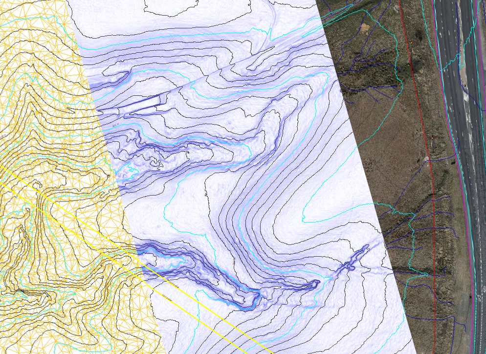
Topographic survey data is extracted and delivered in the preferred file format to ensure compatibility with specialist surveying software.
On a recent project, Diospatial was engaged by Integrated Consulting to provide drone-LiDAR survey and aerial imagery over a parcel of land in regional NSW.
“The LiDAR and imagery capture service provided by Diospatial was not limited to the accurate capture of the difficult topographic detail required for the design of the development. Prior discussions with all consultants working on the project allowed Diospatial to tailor a data capture to fulfill all the projects spatial data requirements, including for Town Planning, Bushfire Planning, Traffic Engineering, Biodiversity and Civil Design.” said Shannon Dawson of Integrated Consulting.
“The data supplied was based on our site datum, came with an easily understandable metadata and accuracy statement, and was in formats easily imported into our survey computation packages. Diospatial staff worked with our survey team to amalgamate data sets where traditional surveying was undertaken to provide a complete and cost-effective spatial data solution for our client.”
QUALITY CONTROL
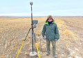
As with all survey and engineering, quality control is critical. LiDAR surveys, unless otherwise required, should be quality controlled in line with the ICSM Guidelines for Digital Elevation Data – an accuracy verification method based on the comparison of LiDAR and derived elevation data with ground surveyed check and validation points and details specific wording which should be used in the metadata reporting and understood by end users.
With every survey, Diospatial provides a report that simply and clearly explains the quality control and validation process, achieved level of accuracy, and any limitations. The report can be easily used and understood by other project stakeholders and provides a robust record of the acquisition, processing, and delivery of the survey.
FIT-FOR-PURPOSE & INTEGRATED
The accuracy achieved with drone LiDAR is typically 50-100mm at 95% confidence in clear and open terrain – while not impossible, a cautious and skeptic approach should be taken with any LiDAR derived data products claiming better than this. In areas where higher accuracy is required, Diospatial can integrate total station and/or GNSS acquired detail with the LiDAR point cloud to develop a TIN model – as is often the case for civil and engineering projects.
ONE SURVEY, MULTIPLE USES
The detail captured in a LiDAR point cloud can also be used to meet the needs of other project stakeholders. In many instances and if required, tree locations and canopy spreads, geological and geotechnical features, vegetation clearances, powerlines and more can be extracted for use by other project stakeholders like town planners, bush fire consultants, arborists, and engineers.
CHECK OUT OUR SAMPLE TODAY
In addition to providing the native files for download and use in third party applications, Diospatial publishes and hosts the deliverables on a secure web-based platform that can be easily viewed, shared, and annotated without the need for powerful computing or specialist software. This increases the utilization of the data and removes the need for additional reports and site inspections.
If you would like more information on implementing drone LiDAR into your firms’ projects, contact Diospatial on info@diospatial.com or check out our free sample data set to see how you can use it.
Diospatial – | 1300 157 964