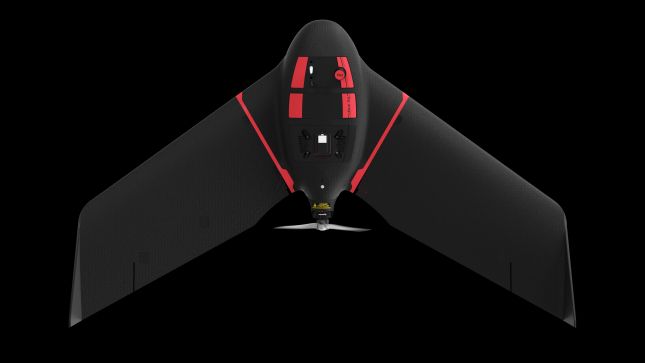
SenseFly has launched eBee Ag, the latest addition to its eBee X series of drones.
Claimed to be user-friendly and affordable, eBee Ag is designed to help farmers, agronomists and service providers capture aerial data and plant health insights for faster agronomic decision-making that can improve crop yields and profit potential.
“The agriculture industry has been lacking a viable mapping solution that offers professional results at a more accessible price,” said senseFly head of marketing Michael O’Sullivan. “The launch of the eBee Ag introduces an affordable fixed-wing solution that delivers the long flight times, range and efficiency—as well as the data quality, accuracy and resolution—that agriculture mapping projects require.”
Based on senseFly’s eBee X drone, eBee Ag helps agriculture professionals overcome the many challenges they face in the field related to planning, plant health and crop monitoring. eBee Ag makes it easier than ever to field scout, ground-truth potential problem areas and gain critical crop health and field information.
eBee Ag is suited for intensive and repeated crop mapping missions. Equipped with its standard battery, it is capable of up to 45-minutes of flight. An endurance battery increases flight times to up to 55 minutes, allowing eBee Ag to cover more than 160 hectares (395 acres) in a single flight, saving time and money when compared with conventional scouting.
eBee Ag incorporates senseFly’s new, lightweight Duet M dual-sensor fixed payload, which comprises the senseFly S.O.D.A. RGB and Parrot Sequoia+ multispectral cameras. With its dual-purpose camera, eBee Ag captures accurate RGB and multispectral data from the sky to help make better decisions on the ground. Regularly collecting multispectral data is critical to effectively assess crop health, optimise inputs and catch early indicators of pests, diseases and weed infestations that threaten crop yields. Highly accurate index maps allow agriculture professionals to understand each acre while managing problematic areas field-wide, before they impact profits.
eBee Agfeatures available real-time kinematic (RTK) functionality for greater mapping precision. With its available RTK, eBee Ag can achieve absolute accuracy down to 2.5 cm (1 in) with RGB. This position data can then integrate seamlessly into existing GPS-enabled machinery and/or farm management systems.
eBee Ag also comes with senseFly’s new eBee X series backpack, which is a smart and durable way to carry everything needed to transport the drone into and out of the field.
Stay up to date by getting stories like this delivered to your mailbox.
Sign up to receive our free weekly Spatial Source newsletter.