The first images produced from data collected by Europe’s newest synthetic aperture radar satellite, Sentinel-1D, have started coming through.
The high-resolution images from Sentinel-1D — part of the European Union’s Copernicus program — were publicly released at the European Space Agency’s Ministerial Council, held in the last week of November in Bremen, Germany.
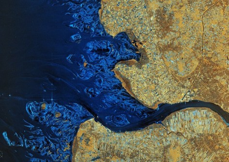
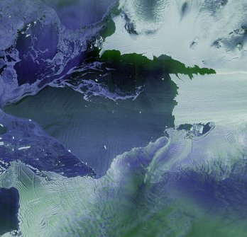
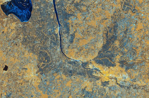
The images show a variety of landscapes, from glaciers in Antarctica, to the southernmost tip of South America, and European cities.
Sentinel-1D was launched on 4 November aboard an Ariane 6 launcher from Europe’s Spaceport in French Guiana.


Satellite stats
Sentinel-1D is the fourth satellite in the Sentinel-1 fleet, the others being:
- Sentinel-1A, launched on 3 April 2014
- Sentinel-1B, launched on 25 April 2016, and
- Sentinel-1C, launched on 5 December 2024
All four spacecraft were launched from Kourou, French Guiana, into polar, Sun-synchronous orbits with an altitude of 693 kilometres.
The spacecraft are 21 m long, 2.5 m wide and 4 m high (figures which encompass two, 10 m-long solar arrays and a 12 m-long radar antenna), have a mass of 2,185 kg and a planned minimum lifetime of seven years.
Other specifications include:
- Primary instrument: C-band synthetic aperture radar operating at 5.405 GHz
- Secondary instrument: Automatic Identification System aboard Sentinel-1C and Sentinel-1D
- Interferometric wide-swath mode at 250 km and 5×20 m spatial resolution
- Wave-mode images of 20×20 km and 5×5 m spatial resolution (at 100 km intervals)
- Strip map mode at 80 km swath and 5×5 m spatial resolution
- Extra wide-swath mode of 400 km and 20×40 m spatial resolution
Speedy results
The satellite’s synthetic aperture radar instrument with its 12-metre-long antenna, was switched on and captured its data during a pass over the Antarctic and South America just two days after launch.
Around six hours later, Sentinel-1D also captured data over Bremen, Germany. The data was downlinked to a ground station in Matera, Italy, part of the Copernicus Ground Segment.
As all of this was achieved within 50 hours of launch, the Copernicus program has suggested that it could very well mark be the shortest time from launch to first data delivery for a radar-based Earth observation satellite.
“These images have been downlinked and processed within an exceptionally short timeframe,” said Nuno Miranda, the European Space Agency’s Sentinel-1 Mission Manager.
“Some of us remember that when Sentinel-1B was launched, it delivered its first radar images within two hours of activation. Sentinel-1D achieved this in an even faster time, setting what we believe is a new record for space radar.
“This remarkable performance reflects the dedication and exceptional preparation of all the teams involved.”
“This is a great achievement and I am so pleased to see these results from Sentinel-1D,” added Simonetta Cheli, Director of ESA’s Earth Observation programs.
“It really places the data we receive from our innovative missions in the spotlight — it is data that we as a society rely upon as we continue to discuss and take action on climate change, and also data that we need in applications for understanding and studying our planet.
“The Sentinel-1 team has done an amazing job and I would like to thank everyone within ESA, together with our partners in the space industry and European institutions, for delivering work of such high quality.”