


Annual mean shoreline change measured in Start Bay, Devon, United Kingdom, from 2018 to 2019.
The European Space Agency’s (ESA) Coastal Change from Space program has used 25 years of satellite imagery to determine changes along 2,800 kilometres of shoreline in the UK, Ireland, Spain and Canada.
Coastlines, particularly sandy coastlines, are in the forefront of climate change, with many suffering due to increased flooding and storm surges as well as slow sea level rise.
Australia has a total coastline length of 60,000 kilometres, only slightly less than that of the European Union at 68,000 kilometres.
It is often said that the majority of Australia’s population lives within an hour’s drive of the coast. According to the European Environment Agency, almost half of the EU’s population lives less than 50 kilometres from the sea.
Part of the data for the Coastal Change from Space project comes from the Copernicus Sentinel-1 and Sentinel-2 missions, which have high revisit rates.
Project scientists developed a process to ensure every pixel from every image has a much improved accuracy on the ground. The process also helps precisely define where the coastline is or was located on a specific date.
These results have been validated by scientists from the four nations using field observations and local knowledge.
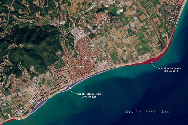
Shoreline change mapped along the coast of Malgrat de Mar, Spain, showing where sandy areas have either accreted or retreated between 1994 and 2019.
“Taking part in this project has enlightened us in coastal surveillance from space,” said Roberto Díaz Sánchez, from the Directorate General for the Coast and the Sea at Spain’s Ministry for the Ecological Transition and the Demographic Challenge
“We are now firmly on the road to a new and promising coastal management paradigm, increasing our chances in successfully adapting our coasts to the effects of climate change.”
The dataset of more than 30,000 images is helping coastal scientists better understand local change processes.
“The datasets being produced under the ESA-funded Coastal Change from Space project have great potential application in Ireland and come at a very opportune time as we are establishing a National Coastal Change Management Strategy,” said Koen Verbruggen, Director Geological Survey Ireland at the Department of Environment, Climate & Communications.
“The coastal change data can help us recognise areas of greatest change, and thus prioritise the allocation of resources at national and local levels.”
Stay up to date by getting stories like this delivered to your inbox.
Sign up to receive our free weekly Spatial Source newsletter.


