

A series of maps depicting areas of Australia that are more or less susceptible to earthquakes will provide important information to help planners mitigate the possible impacts of future earthquakes.
The Earthquake Hazard map of Australia 2012 has been developed by seismologists at Geoscience Australia following investigations into the continent’s earthquake history.
Scientific research by Geoscience Australia into ancient and more recent earthquakes at locations across Australia provides underlying datasets and models for future seismic hazard assessments and for the revision of building design codes, both in Australia and in other stable continental regions worldwide.
Among the inputs to the map is the study of large ancient earthquakes. Geoscience Australia earthquake geologist, Dr Dan Clark, said that, by analysing these earthquakes, direct observations can be made of tectonic movement in large, stable continental regions and estimates can be made of their magnitude.
The estimates of magnitude were obtained by identifying earthquake-related scarps and calculating the largest earthquake considered possible to have created the scarp.
“The record of individual seismic events reflected in the fault scarp can remain in the landscape for periods of thousands of years or more and provide a valuable long-term catalogue of earthquake activity,” he said.
This information has been used to augment the historic earthquake catalogue in the development of the hazard map, which also includes new information on how earthquake energy is dissipated in the Australian crust, and a revised definition of seismically active zones.
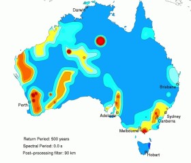
The hazard map depicts the amount of bedrock ground shaking that has a specified probability of being exceeded in a given time period. The contours on this earthquake hazard map are of acceleration in units of gravity with around a 10 per cent chance of being exceeded in a 50 year period, corresponding to a 500 year average recurrence interval, or return period, for this intensity of ground shaking. Those areas assessed to have the highest earthquake hazard in Australia are highlighted in red on the map.
However, even in areas of low to moderate hazard (shaded blue to orange on the map) the pre-historic data indicates that large earthquakes between magnitude 7.3 and 7.7 can still occur anywhere on the continent.
The Earthquake Hazard Map of Australia 2012 is one of the key inputs to the Australian Earthquake Loading Standard.
You can view the map online at: http://www.ga.gov.au/darwin-view/hazards.xhtml


