The Terrestrial Ecosystem Research Network (TERN) is in the process of conducting a standardised, nationwide ecological data collection program in collaboration with teams at University of Adelaide and University of Tasmania.
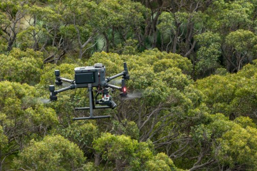
The program is making heavy of drones to gather information at 1,000 ecological monitoring sites much faster than before.
The work will provide data that complements TERN’s current landscape studies and fill the gaps between field surveys and broad satellite image analysis.
According to TERN, there is an increasing need for “robust and accurate calibration and validation datasets with the launch of new satellite missions that will focus on observation of structure (biomass) and ecological processes (productivity)”.
Using TERN’s new standardised methods and collaborative platform to develop and test procedures and data standards, the drones are proving to be reliable tools for ecosystem science, agriculture and land management.
The work involves the use of high-spatial resolution RGB cameras, 10-band multispectral sensors and 3D laser scanners, for mapping landforms and vegetation, tracking livestock, counting animal species.
Importantly, the effort helps with the monitoring of hard-to-reach areas or places undergoing rapid changes caused by climate extremes.
In addition, the development of centimetre-scale resolution data products is providing new insights into ecosystem function and dynamics.
Automated processing and AI classification are making it easier and faster to assess ecosystems, enabling researchers and land managers to quickly evaluate changes and conditions.
Currently, TERN boasts:
- 800 ecosystem observing sites
- 2,500 open data collections
- 90-year continuity for datasets
- 100,000 environmental samples