


A history of landslides (red) overlapped with the road network managed (blue). The town of Quadri has been used as an example to understand which route would be the least vulnerable to movements. Credit: ESA/ANAS/ISPRA.
A new ground motion service utilising Copernicus satellite data is being used by the Italian road agency to detect and monitor unstable ground — helping to improve nationwide road infrastructure safety.
The design and construction of roads and motorways are strongly affected by any movement taking place on the ground. Italy is particularly subject to unexpected ground movement including landslides, subsidence and earthquakes.
Avoiding or mitigating the consequences of such events poses significant challenges for planning, building and maintenance of road infrastructure.
Planetek, an Italian company based in Bari, has developed a ground motion service called Rheticus that provides regularly updated nation-wide maps of ground movement based on data from the Copernicus Sentinel-1 mission. Sentinel-1’s Synthetic Aperture Radar (SAR) instrument allows large-scale maps showing millimetric movements on the ground to be generated.
ANAS, The Italian Roads Authority, is now using Rheticus to assess risk and adapt road designs to reduce the danger for Italian motorways, tunnels and bridges.
The extremely accurate measurements of ground movement will enable road planners and builders to identify the risk of ground instability. As a result, the design of motorways can be made more resilient against future ground-movements.
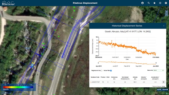
Planetek has developed a ground motion service called Rheticus that provides regularly updated maps of ground movement based on data from the Sentinel-1 mission. Credit: Rheticus.
An example of this is in Abruzzo, where an upcoming road is being constructed, and satellite data, including that from Sentinel-1, have been used to help the planning phase of the project. Using satellite data on a regular basis will enable the detection of smaller ground movements and for potential risk to be assessed.
“Over the past 20 years, we have utilised satellite data in many projects and, where possible, used it to solve landslide related issues often emerging during construction,” said Flavio Capozucca, an Engineering geologist at ANAS who contributed to the study.
“Given the good availability of satellite data in the last years, we have tried to move towards an extensive and preliminary use of all the available information coming from Earth observation, starting from interferometric data, such as the ones from the European Ground Motion Service. These data are fundamental for monitoring and checking the various geomorphological sites and related maps of the Italian territory, which usually are the starting point of any project analysis.”
“Planetek Italia is proud to support ANAS in enhancing its services and reaching its goals with the operational use of actionable analytics based on Copernicus data,” added Giovanni Sylos Labini, CEO of Planetek Italia.
This case study has been analysed as part of the Sentinel Benefits Study (SeBS) which aims at assessing the benefits brought by Copernicus Sentinels to society.
“This case shows just one of the ways in which immense societal value is being created through the use of Sentinel data,” said Geoff Sawyer, Secretary General of the European Association of Remote Sensing Companies, which manages the study for ESA.
“The benefits are not just measured in economic terms but also drive value in many other ways. The Sentinels Benefits Study cases are exposing these benefits for public administrations and businesses for the environment, for regulators, researchers, innovators and for citizens and society.”
The European Ground Motion Service (EGMS), part of the Copernicus Land Monitoring Service, provides consistent and reliable information regarding natural and anthropogenic ground motion over the Copernicus Participating States and across national borders, with millimetre accuracy.
The EGMS operationally uses Sentinel-1 data and represents a baseline for ground motion applications at continental, national and local level, providing ground motion product updates three times a year, typically.
Information courtesy ESA.


