

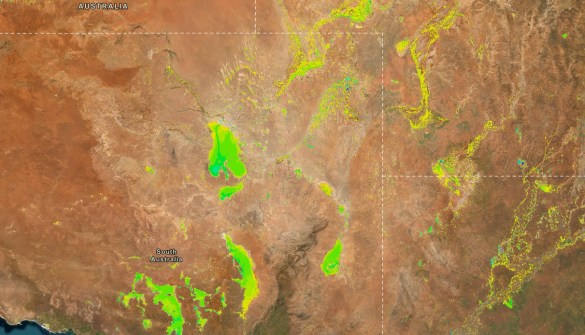
Geoscience Australia has released updated datasets that reveal more than 35 years of satellite-based water observations across the continent.
The Digital Earth Australia (DEA) Water Observations Multi-year Summary datasets are a visual indication of both where and how often surface water has been detected at each location across Australia.
The data have been produced by identifying wet regions as detected in imagery taken by the Landsat series of satellites, from data which has been collected over Australia since 1986.
The data shows not only where water is usually detected, such as in lakes and rivers, but also where it is not usually present, such as can be found during flooding events.
The three DEA datasets are:
- The Water Observations Multi-Year Summary – Water Frequency, which gives the percentage of clear satellite observations that showed surface water;
- The Water Observations Multi-Year Summary – Wet Count, which shows where water has been detected in clear satellite images over time; and
- The Water Observations Multi-Year Summary – Clear Count, which indicates how often an area was clearly visible in satellite images, excluding cloud and shadow.
The datasets can be combined inside the Digital Atlas of Australia with other national datasets to produce bespoke maps to, for instance, understand where flooding may have occurred in the past, gauge how reliable surface water coverage may be in the future, and see how water moves through wetlands and surrounding landscapes.
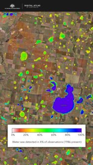
In addition, Geoscience Australia has developed a DEA Water Observations Multi-year Summary Explorer application that brings the three datasets into a single view.
They can also be connected directly into a user’s own portal or system.
Landsat Next
Having been a longtime user of Landsat data, in 2024 Australia signed up to the next stage in the program by becoming formally involved in the Landsat 2030 International Partnerships Initiative.
That Initiative is based on the upcoming Landsat Next satellite series.
Australia has committed $207.4 million to the Initiative over four years, as well as ongoing funding, for enhancing the capabilities of the Landsat satellite ground station in Alice Springs and providing new data processing and analytics capabilities.
The triple-satellite Landsat Next mission, due for launch in 2031, will boost both temporal and spectral coverage, with the satellites spaced 120 degrees apart at an orbital altitude of 653 kilometres.


