Geoscience Australia, in collaboration with the University of NSW and James Cook University, has launched the Digital Earth Australia (DEA) Coastal Ecosystems product suite.
DEA Coastal Ecosystems makes use of Sentinel-2 Earth observation (EO) data for the years 2021 and 2022 to produce 10-metre-resolution maps of four coastal ecosystem types.
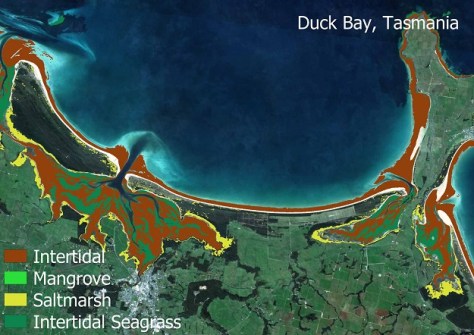
According to Geoscience Australia (GA), it is the first national product to simultaneously map Australia’s mangrove, saltmarsh, intertidal and intertidal seagrass ecosystems, providing users with a consistent, continent-wide view of ecosystem extent and distribution.
GA says the product is derived from a national training dataset of more than 40,000 expertly annotated ecosystem observations, enabling modelling and mapping of ecosystem extents across Australia at Sentinel-2’s 10-metre resolution.
DEA Coastal Ecosystems is suitable for a range of applications such as environmental management and reporting, coastal risk modelling and ecological change assessment.
Key features of the product suite include:
- Sentinel-2 10m resolution derived classified ecosystem maps for 2021 and 2022 defining dominant ecosystem extents of mangroves, saltmarsh, intertidal, and intertidal seagrass.
- Probability layers for mapped ecosystems to enable user interpretation of mixed and transitional classes.
- QA/QC layers to provide confidence and assist in product interpretation.
- Publication of ancillary layers used for masking and constraints in the mapping workflow.
- Publication of the national training dataset, metadata, classification schema and acquisition protocol.
Full details can be found on the Knowledge Hub, and a StoryMap has been produced that enables users to explore and zoom in anywhere along Australia’s coastline.