

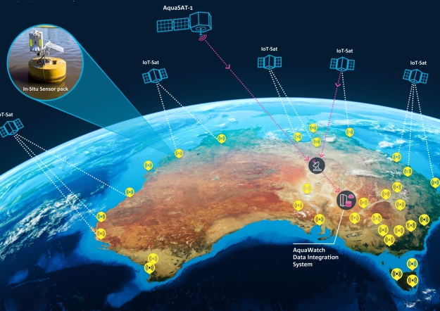
Artist’s impression of the AquaWatch system including in-situ water sensors, remote satellite sensors, data hub for integration of sensor data and AI modelling. Credit: CSIRO.
CSIRO has launched AquaWatch Australia, a project to deliver a world-first, ground-to-space water quality monitoring system for Australia and the globe.
Once fully operational, AquaWatch will provide near real-time updates and predictive forecasting – effectively a weather service for water quality.
The project will use a network of Earth observation satellites and ground-based water sensors to provide early warning of harmful events such as toxic algal blooms, blackwater and runoff contamination.
CSIRO, along with foundation partner SmartSat CRC, is bringing together the research sector, government and industry with an initial co-investment of $83 million to design and develop AquaWatch.
CSIRO Chief Executive, Dr Larry Marshall, said water is one of the most important and vital resources in Australia and across the globe.
“Imagine taking your family to the local swimming spot and being able to open your phone and check the water quality before they dive in. Or better yet, getting a forecast for the water quality days before you planned your family day out,” he said.
“Now imagine the impact of this if you were an environment manager, able to receive advance warning of the oxygen-depleted blackwater events often responsible for mass fish kills. Or an aquaculture farmer able to plan ahead for an impending algal bloom.
“Overseas, in places where people still face the risk of unsafe water for basic needs like drinking and sanitation, such a service could be a game-changer.”
AquaWatch integrates Earth observation with other science capabilities such as in-situ sensing, ecosystem modelling, engineering, data science and AI.
Working with a range of implementation partners, AquaWatch will extend from rivers to coasts, with the ability to monitor bays, coastal wetlands, aquaculture farming, mangrove forests and coral reefs, including the Great Barrier Reef.
SmartSat CRC Chief Executive Officer, Professor Andy Koronios, said that space technology will be a key aspect of AquaWatch and essential to developing an accurate understanding of Australia’s water systems.
“The initial suite of co-operative projects brings together research partners, government and industry and cover integrated ground-to-space water quality monitoring systems for inland, estuarine and near-coastal water bodies,” he said.
“This collaborative effort to harness the data gathered from satellites will play an essential role in safeguarding our future water supply and improving our natural environments,” he said.
Data from both the sensors in the water and on the satellites will be integrated at a central data hub where CSIRO’s capability in data analysis and AI can provide forecasts a few days ahead.
AquaWatch already has six pilot sites set up around the country to test the system for several uses, such as monitoring toxic blue-green algae blooms at Lake Tuggeranong in Canberra.


