


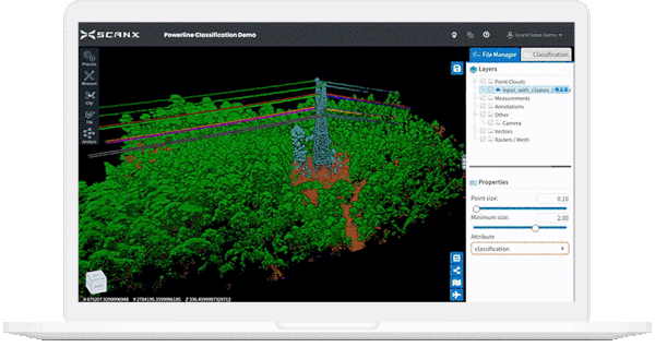
ScanX Cloud’s machine learning algorithms automatically classify point cloud data for more accurate insights
Brisbane and Tokyo-based software start-up ScanX offers a new cloud-based platform to upload and automate surveyors’ 3D point cloud data using artificial intelligence. The system eliminates the time consuming task of manual processing by automatically and accurately classifying points into classes such as ground, vegetation, and buildings.
ScanX Cloud has managed to hand over the hard work of 3D classification to the artificial intelligence. The system uses efficient batch servers to post-process very large datasets acquired from all types of scanners and the result is an accurate 3D model all accessed by only your web browser.
Enterprise users get access to advanced analytics such as auto-generated ground contours, road analytics, tree segmentation, and sharability group settings.

Scan X Cloud utilises AI for automated vegetation classification
ScanX was founded by a pair of engineers with years of experience doing field scanning and processing work, spending hours painting, slicing, moving contours and making their scans clean enough to use for their intended purpose.
This experience was the inspiration for ScanX and has been directly folded into the platform’s robust backend processing.
ScanX’s Brisbane based CTO and co-founder Hong Tran says because they knew the process from their own experience, they were able to design a fully automated system that accomplishes the same tasks accurately, but much more quickly.
“It’s kind of like we’ve done all the hard work for you. We do the onsite filtering and cleaning, and we handle all the cloud processing, so we batch process everything,” Hong says.
ScanX Cloud allows teams to track, monitor and measure projects on and off-site.
Traditionally, it takes surveyors more time to process the 3D data than to capture the data. ScanX can automatically extract the ground points from a 10GB point cloud data in less than 2 hours, saving surveyors signification PC post-processing time.
“3D Mapping data from the web is the perfect way for enterprises to add value to their existing data and to shift into software automation without the overheads,” says ScanX CTO Hong Tran. “They can automate data and share it with people who do not have access to complex and expensive surveying software.”
The ScanX Cloud portal itself is also designed to be intuitive and easy to use. Upon entering the platform, the user chooses the type of scanner, and then has several options for choosing resolution and defining what will be cleaned up, including the removal of duplicate points. Then the scan file can be dropped into the interface and it will be processed in the cloud.
By providing a central, web-based platform, ScanX can also assist with the integration of data from multiple sources. By centralising, organising and making the scans readily available when needed, multiple stakeholders are able to pull up the critical information at the same time from varied locations, and the valuable analysis won’t be stuck on the computer of a particular surveyor.
Additionally, ScanX Cloud can output to many surveying software platforms.

ScanX is currently offering a free 14-day trial of its new cloud-based platform
This solution is great for surveying companies that are limited in:
- A digital platform to process and analyze 3D point cloud data from surveying devices (Terrain Laser Scanner, Mobile LiDAR, UAV LiDAR)
- Mining companies measuring safety compliance in roads and infrastructure (road widths, gradients, and windrow heights)
- Construction stockpile measurements – ability to extract only stockpile ground points for asset management
- Forestry management – automatically count the number of trees, truck, and canopy diameters
- Sharing 3D point data – with only internet access and a web browser, guest users get secure access to up to date accurate scan data of sites
ScanX users can choose from three tiers of services: Free, Business and Enterprise plans. A 14-day free trial is available and monthly plans start at $299 (US) per month to suit a variety of user needs. Interested users can register for the free trial at https://scanx.com/try-for-free/.
Information provided by ScanX


Comments are closed.