 DMS + GIS: the integration transforming asset data management for critical infrastructure operators and complex asset owners with real time spatial insights.
As organisations progress down their path of digital transformation, the need for tighter integration between different technology stacks is becoming ever more critical.
Asset managers for example, are acutely aware of the challenges of managing complex critical infrastructure assets, which are often geographically dispersed or located in remote areas.
 In many cases, the asset data and drawings that represent those assets are paper-based. Field crews cannot be certain they’re working on the most up-to-date drawing. This presents safety risks and also results in inefficient work processes. Updating paper drawings on-site often means those changes are never reflected in the version of the drawing held by head office. No longer does the organisation have an accurate view of its assets.
Another challenge for asset managers is either not having accurate geospatial information about each asset – or not having this data in a format that makes it quick and easy to use when responding to disasters or urgent maintenance needs.

– RedEye Founder and CEO
Wayne Gerard.
For example, if a power utility had substations located in the path of a destructive bushfire, key stakeholders would ideally be able to pull up a map and drawings of the potentially impacted assets, assess the risks and take appropriate actions to minimise outages or damage.
With many organisations storing their asset data across disparate systems and having asset management and GIS teams which may have different priorities, the ability to respond quickly to urgent or business-as-usual situations can be diminished without the right systems doing the heavy lifting.
The logical integration of DMS and GIS
In working with asset-intensive organisations around the world, Australian technology developer, RedEye, saw the growing need to support both asset managers and spatial teams in creating a single source of truth for asset data.
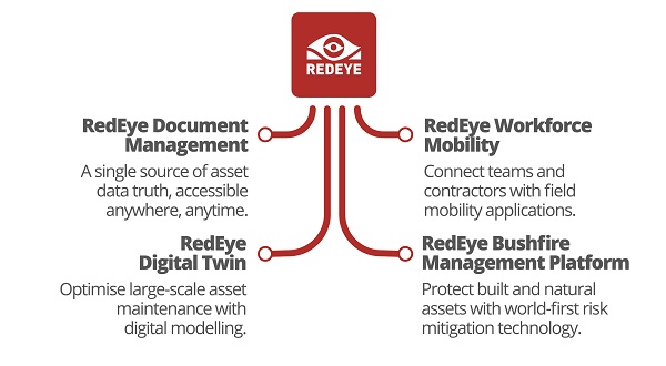
 Providing a range of products that help manage critical infrastructure operations across the globe, their SaaS solutions help large complex asset owners and operators manage and maintain their assets throughout the complete asset lifecycle. From launching digital transformation and replacing paper-based asset data to connecting teams and contractors for efficient and compliant field maintenance work and optimizing asset operations with 3D modelling through digital twin representations right through to protecting built and natural assets with world first bushfire risk mitigation solutions.

Redeye’s integrations
RedEye’s cloud and mobile based technology platforms integrate with and compliment your exisitng ERP, EAM, safety and other core business systems. This new integration adds GIS to the mix, integrating with leading GIS solutions like Esri, 1Spatial and Seisan or any GIS based system, improving access to your asset information. RedEye’s configurable workflow engine, review and approval tools and visual timeline makes managing changes seamless and ensures your staff and contractors are always working off the correct and up-to-date version of your engineering drawings, maintenance manuals, safe work procedures and other critical asset information.
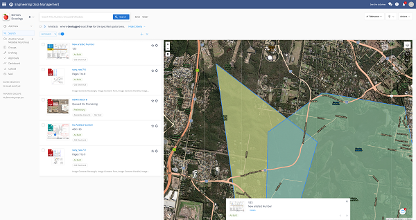
The new GIS integration features extend RedEye’s spatial capabilities, allowing users to create geospatial boundaries on a map and search for drawings and documents within that defined area. Spatial information (points, lines, polygons) from the GIS is stored with relevant asset drawings and documents in DMS.
Users can search for artefacts using a combination of a geospatial boundary and standard search filters. They can also zoom in and out of an area on the map to narrow or widen search results.

Users can create geospatial boundaries on the map view within RedEye DMS and see related asset data from within that defined area.
In the power utility example, an asset or GIS manager could now use RedEye DMS to draw a boundary around the scope of the fire threat, quickly zoom into the impacted area via the map, identify any tagged assets, and see all of the associated drawings, documents and media related to those assets.
Similarly, the geographic zoning feature could be used to improve safety on mining sites and any other sites where field workers need to be aware of hazardous or security-restricted areas.
If for example, an engineer arrived onsite to complete maintenance work, they could use the RedEye DMS mobile application to quickly pull up relevant location-based isolation procedures, including drawings and other media. They could see at a glance, how to isolate a specific piece of equipment in order to work on it safely.
Like any common mapping functionality, maps can be displayed through RedEye DMS in street, 3D, and aerial view. Organisations can choose to use the provided base maps and add their own map layers if they choose.
Drawing a seamless path to digital transformation
This seamless integration of DMS and GIS provides real time spatial insights of critical assets, giving asset managers greater visibility and control of their assets.
“RedEye was founded on the need to help large complex asset owners and critical infrastructure operators improve asset safety and performance with a user-friendly Software-as-a-Service (SaaS) solutions,” said RedEye Founder and CEO, Wayne Gerard.
“Integration with core business systems has always been a focus for us. When organisations connect their core systems with RedEye, their asset data becomes more available, usable and valuable. Today we help our clients manage over $250 billion in assets,” he said.
“We understand the challenges asset managers face, as well as the drivers from a C-suite perspective to integrate business systems. Managing asset data is a critical first step in any digital transformation. Overlaying spatial capabilities provides an additional level of visibility which has exciting potential for use cases across all sectors.”
To find out more about the power of DMS + GIS, visit www.redeye.co/GIS
Information provided by RedEye.


Comments are closed.