

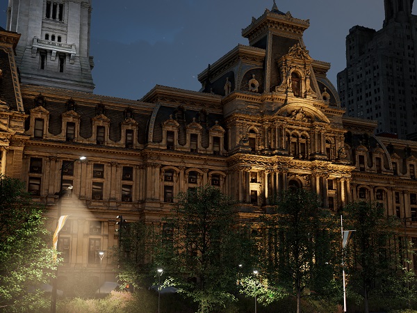
Aerometrex uses dynamic lighting for the ultimate real-time visualisation of 3D mesh models.
The geospatial and gaming industries have a common goal that’s pulling them closer together: accurately reproducing the real world. That’s causing a convergence for both sectors that presents a compelling opportunity for spatial professionals.
Aerometrex pays close attention to GIS visualisation systems for showcasing its high-resolution aerial imagery, 3D modelling, and LiDAR data. They are firm believers that gaming engines have a significant role to play in the future of real-time spatial visualisation and vice versa.
WHAT ARE GAME ENGINES?
In short, game engines are the building platforms for video games. They are to the games industry what ArcGIS, AutoCAD, or GeoMedia are to the geospatial industry.
Strip back the differences between the spatial and gaming industries and the common goal is accurately rendering the real world into the virtual one. Game engines are, at their core, staging and simulation environments. They’re creativity sandboxes at the centre of a global industry worth tens of billions per year, waiting for input data and output parameters.
PHOTOGRAMMETRY AND LIDAR IN GAMES – ADDING MEASUREMENT AND FIDELITY
There’s a symbiotic relationship between gaming and geospatial sectors. As game engines become better real-time visualisation platforms, ever-improving geospatial products like LiDAR, orthoimagery, and photogrammetry add greater measurement accuracy and visual fidelity to games.
Games aspiring to real-world reproduction are turning to companies like Aerometrex for ways to bring geospatial data into games. Games like Forza Motorsport, Call of Duty: Modern Warfare (2019), and Star Wars Battlefront have used photogrammetry and LiDAR to recreate everything from specific movie props, forests and mountain ranges, and real-world racetracks.
Aerometrex has ingested their high-resolution 3D models from Adelaide, Denver, Pau, and Philadelphia into Twinmotion and Unreal Engine to test their real-time visualisation capabilities. The company has also developed AI-driven semantic classification to separate and replace specific objects from photogrammetry models and make texture enhancements. The system identifies cars, trees, and classified features to be hidden from the visualisation, or replaced by pre-made game assets.

Adding realistic people and objects into 3D models turns them into living scenes.
INFRASTRUCTURE MARKETING AND PROJECT SHOWCASING
Game engines can already take over a specific and lucrative role for the geospatial, architecture, engineering, and construction industries: marketing asset creation.
Whether a road, bridge, building, or housing development, game engines give you the best opportunity to create an emotional connection because of the realism they offer. Showcasing your large scale project has become integral to the modern spatial industries. Quality real-time renders are powerful assets during the tender process, drive sales, and help with stakeholder engagement. The spatial industry opportunities from game engines are substantial: creating interactive 3D worlds and experiences unmatched by any traditional spatial industry or marketing tools.
THE HUNT FOR IMMERSION
The push for immersive videogame experiences is perfectly crafting game engines for impactful real-time GIS visualisation.
Dynamic lighting, realistic weather, and photogrammetry asset libraries make for a rich and diverse staging environment that can change to reflect real-world conditions. An architectural firm can re-create a fully-furnished apartment building and show real-world lighting to prospective buyers who can digitally walk through the property. Housing developments can model an entire neighbourhood before it’s built and let people experience the space in virtual reality. Large infrastructure projects can place new structures within a city model and show a bridge or building as it will exist in the real world.
CROSS-INDUSTRY INTERESTS
Some of the biggest names in the gaming industry are actively building and adapting platforms for geospatial visualisation. The spatial industry’s size and value are too substantial for the gaming industry to ignore.
Both Unity and Unreal-Engine can import spatial data as FBX, elevation data as height map and corresponding imagery to drape on top. ESRI CityEngine can directly export data into Unreal Engine Datasmith format. Datasmith is a collection of tools to bring CAD, BIM and GIS content to Unreal Engine. Complex 3D environments streamable to any web browser via Pixel Streaming. Unreal Engine provides tools to manage large terrain-based worlds such as Landscape and World Composition.
The development clout of gaming companies is bringing down usability barriers and making for streamlined creativity products. Aerometrex has begun leveraging real-time game visualisations. City models populated with humans, moving vehicles, dynamic lighting, and weather effects get made quickly by ingesting 3D models built from photogrammetry. Fly-throughs and cinematic video outputs are edited together and published on the internet for engaging marketing content.
WHERE TO LEARN MORE
The industry crossover is still early for spatial and gaming, but there will likely be a first-mover advantage for those who learn the newly emerging ecosystem. Those wanting to learn more about game engines can follow Epic Games, Unity and Twinmotion or see Aerometrex for examples of how real-time visualisations are used.
Information provided by Aerometrex.


